Golden Trout Gambol, California
Sierra Club Outings Trip | Backpack
Highlights
Includes
Overview
The Trip
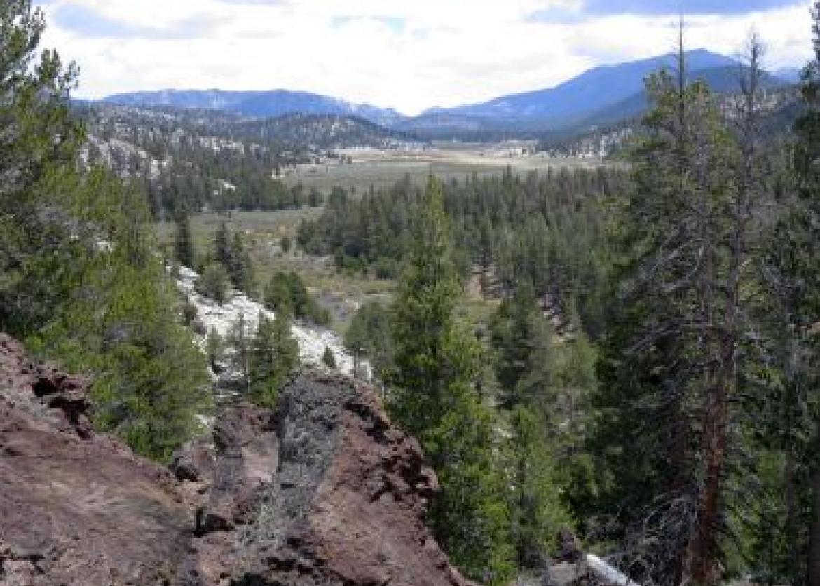
The Golden Trout Wilderness in the Southern Sierra is a hidden gem. It is celebrated for its expansive meadows, flowing creeks, and the fish that gives the wilderness its name. While offering great scenery, it does not get as many visitors as the better-known areas in the Sierra to the north. We may go several days without seeing other backpackers. The terrain itself tends to be more open and gentle; not as rocky and granitic. Our nearly all on-trail loop route runs through the high northeastern portion of the wilderness. The route starts off on the edge of the high rocky Sierra, lasts for a time on the Pacific Crest Trail, and then heads into the core of the Golden Trout, providing a nice variety of terrain. Most of our camps will offer ample opportunities for peace and solitude
The Trip
The Golden Trout Wilderness in the Southern Sierra is a hidden gem. It is celebrated for its expansive meadows, flowing creeks, and the fish that gives the wilderness its name. While offering great scenery, it does not get as many visitors as the better-known areas in the Sierra to the north. We may go several days without seeing other backpackers. The terrain itself tends to be more open and gentle; not as rocky and granitic. Our nearly all on-trail loop route runs through the high northeastern portion of the wilderness. The route starts off on the edge of the high rocky Sierra, lasts for a time on the Pacific Crest Trail, and then heads into the core of the Golden Trout, providing a nice variety of terrain. Most of our camps will offer ample opportunities for peace and solitude.
The Golden Trout Wilderness was established fairly late (1978) and cattle grazing in four allotments was initially grandfathered in. Two allotments have been closed on an interim basis to cattle grazing for over a decade. All but one day of our route is in the closed allotments, which we will enjoy cattle-free. We will have the opportunity to witness the recovery of these meadows and their creeks. The Forest Service is considering returning cows to these areas in 2017. We will learn how to participate in the process to keep them closed to grazing permanently. Your participation in the outing itself is a good start toward this goal.
The trip will start and finish at the Horseshoe Meadows Campground, southeast of the town of Lone Pine, CA.
Itinerary
Our hiking schedule is not rigid and the itinerary described here should be taken as a general plan. We have scheduled the trip early in the season to ensure we have sufficient water. A high snow year or other factors may cause us to alter the route.
Day 1: We will meet at 4 p.m. at the Horseshoe Meadows Campground, our starting and ending point, to get acquainted, distribute commissary gear, and check our equipment and packs. The 10,000-foot altitude will help us get acclimated, and you may even chose to spend some time here the day before as well to acclimate further. Our first group meal will be dinner tonight
Our hiking schedule is not rigid and the itinerary described here should be taken as a general plan. We have scheduled the trip early in the season to ensure we have sufficient water. A high snow year or other factors may cause us to alter the route.
Day 1: We will meet at 4 p.m. at the Horseshoe Meadows Campground, our starting and ending point, to get acquainted, distribute commissary gear, and check our equipment and packs. The 10,000-foot altitude will help us get acclimated, and you may even chose to spend some time here the day before as well to acclimate further. Our first group meal will be dinner tonight.
Day 2: On the first moving day, we hike five miles, climbing 1,200 feet over Cottonwood Pass and then lateraling on the Pacific Crest Trail (PCT) to our campsite at Chicken Spring Lake -- the only lake we camp at and, at 11,240 feet, nearly the high point of the trip. This will be our one busy campsite as it is a major stopping point on the PCT.
Day 3: On today’s five-mile hike, we return to the PCT and gain several hundred feet to reach the high point of the trip, near 11,500 feet. Then largely contouring on sandy tread, we take in views -- first of Big Whitney Meadow and then of starkly beautiful Siberian Outpost -- before turning north on the Siberian Pass Trail. Here the backside of Mt. Langley and the jagged Sierra Crest come into view. We’ll camp at Rock Creek at about 10,800 feet, slightly inside Sequoia National Park. Nearby Soldier Lakes is a great easy, short day-hike destination.
Day 4: We retrace our steps south on the Siberian Pass Trail, gain 400 feet to cross the PCT, and continue on fairly level tread through the edge of Siberian Outpost to 10,900-foot Siberian Pass. From there, we descend 1,000 feet on occasionally faint trail to expansive Big Whitney Meadow. Now in the heart of the Golden Trout Wilderness, we meet the creek of the same name, our companion for the middle section of the trip. Here in the meadow, we’ll also get our first look at the generally small but colorful Golden Trout fish. After passing all the way through the meadow, we'll descend gradually along the creek into its generally broad canyon to camp at about 9,500 feet, for a total distance of eight to nine miles.
Day 5: We continue south, descending gradually along Golden Trout Creek for two miles to the southern environs of Tunnel Meadow, named for the tunnel that attempted to siphon off water from Golden Trout Creek into the nearby South Fork Kern. An active automated weather observation station is located there. Then we turn west and continue descending gradually along volcanic formations for four miles to camp anew along Golden Trout Creek in the vicinity of Little Whitney Meadow, at 8,400 feet elevation, the low point of the trip. The southern half of Little Whitney Meadow is fenced off so horses can run free. We expect to camp outside the horse enclosure. Total elevation loss is about 1,000 feet in a distance of six miles.
Day 6: Today we’ll enjoy a layover day with an optional hike along the creek as it drops 2,000 feet to join the main branch of the Kern River in the long, deep, north/south-oriented Kern Canyon. If we go all the way, it’s 10 miles round trip. However some stops along the way, such as Natural Bridge, are nice turn-around points. Other possibilities include exploring the nearby meadows and Malpais (Bad Country) lava flow, fishing, or just relaxing.
Day 7: We will reverse our course today, heading to the east, but on new trail as we pass along the south side of the lava flow to go all the way through Volcano Meadow. We briefly climb steeply up and more gradually over and down the ridge on the east side of the meadow to rejoin Golden Trout Creek. Here we may need to scout for a crossing due to beaver activity and willow growth. Once across, we rejoin our trail from day five to continue east back to Tunnel Meadow, at this point having gained about 700 feet total. From there we turn southeast to follow the South Fork Kern in a gradual descent for four miles to reach our campsite at 8,700 feet at the far end of Ramshaw Meadows. The distance is nine miles, with a short cross-country segment through the edge of the meadow to our secluded campsite.
Day 8: Our last hiking day is also the hardest day, with the greatest distance, 10 miles, and the greatest elevation gain, 2,000 feet. But fortunately our packs will be light and we’ll be acclimatized to the altitude. Turning north, we cross Ramshaw Meadow on trail and then ascend steeply about 900 feet to a saddle in the broad ridge that separates us from Mulkey Meadows, the first actively grazed meadow we will come to. After a nearly level stroll through Mulkey Meadow, we gain 1,100 feet to cross 10,500-foot Trail Pass, and begin an easy 500-foot descent to Horseshoe Meadows and the end of the trip. Our packs will be light, but we’ll be hit by the bittersweet realization that we're nearing civilization. No matter -- going to the mountains has replenished us and nature's power over man has been proven again.
Logistics
Getting There
We will meet on Saturday, June 18 at the Horseshoe Meadows trailhead campground, on the east side of the Sierra, 23 paved miles (and 6,400 feet up!) from Lone Pine, CA. A map and more detailed directions will be sent to those registered for the trip. The closest cities with major airline service are Los Angeles (a 250-mile drive), Reno (280 miles), and Las Vegas (330 miles, or 250 miles via Death Valley National Park). The San Francisco, Oakland, and San Jose airports in the Bay Area are a full day’s drive at 380 miles plus crossing the Sierra.
A list of participants will be provided so that you can arrange carpools amongst yourselves.
Our last day involves a substantial hike; indeed it is the longest day. For those flying home, the only practical option is to fly out the following day, on Sunday June 26.
Please do not make non-refundable travel arrangements until notified to do so by the trip leader.
Accommodations and Food
The first meal included in the trip will be dinner in the campground on the first day. The last meal will be lunch on the last day. Trip participants will share cooking and meal clean-up duties. The menu will lean toward vegetarian, though some meals will include meat options as well. We will have plenty of food carefully squeezed into the bear canisters, so there's no need, or space, for additional personal food. If you have dietary restrictions, please check with us well in advance of the trip about whether we can accommodate them.
Trip Difficulty
This trip is rated 3 on a scale between 1 and 5. The 3 rating is an average and needs to be put in context with the whole spectrum of backpack trips that we offer, all of which are difficult, just to varying degrees. The total distance, all on-trail except for two short easy off-trail excursions, is about 42 miles. The first and last days have the greatest ascents, 1,200 feet and 2,000 feet respectively. Campsite elevations range from 8,400 to 11,200 feet. You need prior backpacking experience to be sure this sort of trip is right for you.
Conditioning is extremely important for both pacing and altitude considerations. You should have a regular strength and endurance fitness routine involving serious day hikes and leg strengthening exercises. Upper body and core exercises will ease getting your pack on and off. We strongly encourage you to complete at least one early-season weekend backpack before this trip.
Camping at the first night’s trailhead (10,000 feet) will help us acclimate to the altitude. You may wish to come a day before that and do some hiking in the area, particularly if you don’t have recent experience at altitude and don’t know how you will likely respond. Arriving early also makes it easier to recover from a delayed flight or missed connection and make it to the trailhead in time.
Equipment and Clothing
A detailed equipment list will be sent to all registered participants, and a general list can also be found at www.knapsack.org/basic_equipment.html. Be prepared for the extremes of our high-altitude environment. Make sure your tent will keep you dry, and don't skimp on rain jacket and pants (no ponchos). At the same time, try to limit your personal gear to 25 pounds or less. Nighttime temperatures may be below freezing. Your sleeping bag should be rated down to at least 20 degrees, depending on how warm you sleep. You will also need good hiking boots with lug soles that are well broken in. The Club will provide commissary equipment, including pots, cooking utensils, stoves, bear canisters, and other essential group equipment. Expect to carry up to 15 pounds of group food and gear, including a bear canister (up to 13 inches tall by 9 inches in diameter).
References
Maps:
- The Tom Harrison “Golden Trout Wilderness” map covers the entire route.
- Five 7.5 minute series maps are needed to cover the entire route. Getting two to three custom topo maps printed from an internet source may be more practical. The topo maps are:
- Cirque Peak
- Kern Peak
- Johnson Peak
- Mount Whitney
- Templeton Mtn.
Books:
- Swedo, Suzanne, Hiking California’s Golden Trout Wilderness.
- Pacific Crest Trail: Southern California. Wilderness Press.
- Jenkins, Exploring the Southern Sierra: East Side. An older but still useful reference that is no longer in print.
- Laws, John Muir, The Laws Field Guide to the Sierra Nevada. California Academy of Sciences. A general reference to Sierra life. It covers trees, wildflowers, fish, reptiles, amphibians, birds, mammals, and other life in the mountains.
Conservation
The Sierra Club is focused on the environment. We are concerned about conservation and sustainability of resources, both locally and globally. Volunteers aided and encouraged by a salaried staff accomplish our work. Our outings seek to empower participants toward greater understanding, advocacy, and participation in the goals of the Club.
The area of this trip has a specific current issue. The Golden Trout Wilderness was established in 1978 with significant Sierra Club involvement. At that time, four existing cattle allotments where grazing had occurred historically were grandfathered into the wilderness. Two of the four allotments (Whitney and Templeton) have been rested since 2001, and the recovery of the meadows is being studied to determine if grazing should return, possibly as soon as 2017. The scoping process for this decision, to be made by the Forest Service, has been delayed multiple times, but is expected to start in January of 2016. We will learn about this process, how meadow health is assessed, and the role we can play in keeping these meadows cow-free.
Sierra Club National Outings is an equal-opportunity provider and will operate under permits from Sequoia & Kings Canyon National Park and Inyo National Forest.
Staff
Photos
Important Notes
- Carbon Offsets
- Carpooling
- Electronic Billing and Forms
- Electronic Devices
- Equipment
- Essential Eligibility Criteria
- How to Apply for a Trip
- Leader Gratuities
- Medical Issues
- Non-discrimination Statement
- Participant Agreement
- Seller of Travel Disclosure
- Single Supplements
- Terms and Conditions
- Travel Insurance
- Trip Feedback
- Trip Price
- Wilderness Manners