Leisurely Loops Among the Lakes of Plumas County, California
Sierra Club Outings Trip | Base Camp
Highlights
Includes
Overview
The Trip
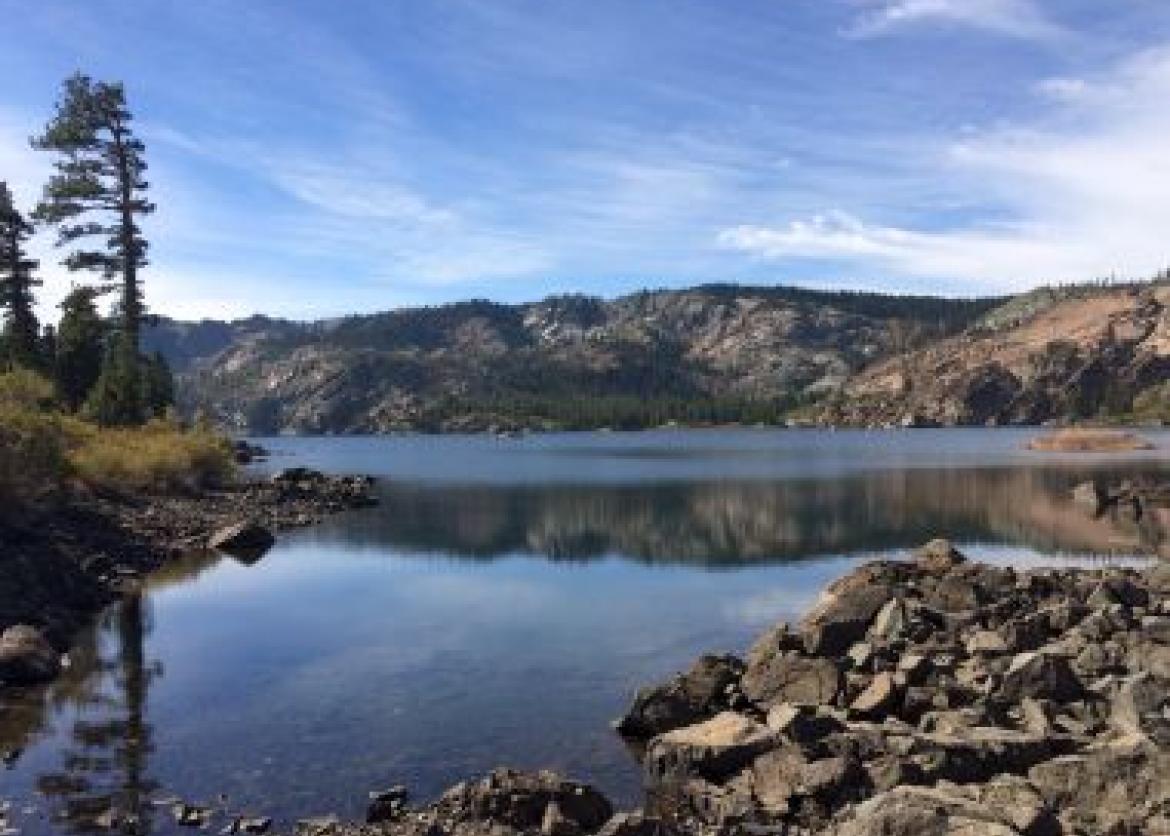
Tucked into the northern Sierra Nevada range is a hidden gem: the Lakes Basin of Plumas County. Named for the nearly 50 alpine lakes that dot the granitic basin, it is one of northern California’s more beautiful and most accessible areas. Formed by glaciers, the rich and moist soils of the area are known for the profusion of summer wildflowers. Clean air, sweet-smelling pines, and abundant wildlife await those who visit.
The lakes are encircled by many interlocking trails, affording hiking options from flat meadows to steep mountain ascents, and from short strolls to long loops. Many of the lakes and streams have excellent fishing. Our trip is a base camp experience designed to provide various choices to participants, and whose focus will be walking at a relaxed pace. We will definitely take time to smell the flowers … and to note the birds, trees, and la
The Trip
Tucked into the northern Sierra Nevada range is a hidden gem: the Lakes Basin of Plumas County. Named for the nearly 50 alpine lakes that dot the granitic basin, it is one of northern California’s more beautiful and most accessible areas. Formed by glaciers, the rich and moist soils of the area are known for the profusion of summer wildflowers. Clean air, sweet-smelling pines, and abundant wildlife await those who visit.
The lakes are encircled by many interlocking trails, affording hiking options from flat meadows to steep mountain ascents, and from short strolls to long loops. Many of the lakes and streams have excellent fishing. Our trip is a base camp experience designed to provide various choices to participants, and whose focus will be walking at a relaxed pace. We will definitely take time to smell the flowers … and to note the birds, trees, and landscapes we see.
For those who wish more of a challenge, two steep hikes may be available that offer stunning views of the surrounding forest and lakes. Sierra Buttes, the highest local peak at 8,587 feet, has a fire lookout that one can climb to.
The base elevation for our week’s relaxing camp is around 6,400 feet. Nights are cool, and days are usually sunny but not too hot. There is always the possibility of rain in the mountains. Besides hiking and fishing, our location is wonderful for bird watching, sketching and painting, star-gazing, and simply relaxing. The nearby communities of Graeagle and Blairsden have quaint shops and yummy bakeries.
Itinerary
Day 1: Participants will be sent a trip roster so they can arrange carpooling, if desired, from Reno or Sacramento airports to our campground. Starting at 3:00 p.m., we will gather (with snacks available), put up tents, make introductions, and then have dinner together around 5:30 p.m.
Days 2-6: We will plan daily hikes of up to eight miles (with elevation gains ranging from 50 feet to the most strenuous possibility of 2,000 feet), with many shorter options, based on weather, group capabilities, and preferences. The leaders will provide maps, advice, and guidance each day. Those who wish can opt to remain in camp or fish nearby (California fishing license required).
Day 7: After breakfast all participants will help pack up the group commissary, then we'll make our good-byes.
Logistics
Getting There
Participants are welcome to drive to our campground, provided they let the leaders know of their plans; we are limited as to the number of cars allowed. Detailed driving instructions will be sent to those who request them.
The nearest airport is the Reno-Tahoe International Airport, 60 miles away in Reno, NV. Car rentals are available at the airport. The drive to our location takes 1 to 1.5 hours, depending on the route
Getting There
Participants are welcome to drive to our campground, provided they let the leaders know of their plans; we are limited as to the number of cars allowed. Detailed driving instructions will be sent to those who request them.
The nearest airport is the Reno-Tahoe International Airport, 60 miles away in Reno, NV. Car rentals are available at the airport. The drive to our location takes 1 to 1.5 hours, depending on the route.
Sacramento International Airport, CA is 150 miles to the west, and a drive from there will take about 3 hours. Car rentals are also widely available at this airport.
Please do not make non-refundable travel arrangements until advised by the leader.
Accommodations and Food
We will be staying in the one group site available at the Lakes Basin Campground. Leaders will bring all commissary equipment and dining tarps, while participants will bring their own tent, sleeping pad, and sleeping bag. There are no showers at the campground, but we will be providing both a men’s and women’s shower area, created from tarps, where we will hang solar showers to provide brief bathing. Let’s hope for sunny days so we have plenty of warm water! Vault toilets are available.
All meals and snacks are provided for this outing. Your leader loves to cook outdoors, and has received numerous compliments on her camp meals. You will be well fed! Sierra Club participants normally assist with meal preparation and clean up.
Trip Difficulty
The hikes on this trip can range from easy to strenuous, but most will be in the easy to moderate range. The better shape you are in, the more you will enjoy the outing. The outing is appropriate for experienced hikers as well as for those who may not have had much time on the trail recently, but all hikers need to have the ability to walk for at least five miles on uneven terrain at a pace of approximately two miles per hour.
Trails in the area can be wet or muddy in June, and footing can be unstable in some rocky areas. The steeper hikes have areas of rock scree and exposure that could be unsettling to those without good balance.
There are many intersecting trails in the outing area, so we will hike as a group or possibly in two groups; we don’t want anyone to get lost by hiking without a leader.
Equipment and Clothing
The equipment needed for this outing is typical for a mountain base camp. Tents need to be tested for their rain-worthiness. A sleeping bag rated for 25 degrees or lower will be welcome at night, even though temperatures are not expected to be that cool.
Campers will provide their own mug, plate, bowl, and cutlery.
Each hiker needs well broken-in hiking boots or shoes that can stand getting wet. Layered clothing and good rain gear are advisable. Trekking poles can be helpful. A detailed list of clothing and equipment will be sent to all approved participants.
References
- DeMund, Tom, Feather River Country Adventure Trails.
- Laws, John Muir, The Laws Field Guide to the Sierra Nevada.
- Young, Jim, Plumas County: History of the Feather River Region.
- Dixon, Roland Burrage, The Northern Maidu.
Conservation
The Sierra Nevada mountain range is a vast area of great importance to all communities in California. Over 60% of the state’s developed water supplies originate here, so the impacts of drought and a warming climate will be prominent topics for discussion on this outing. As we talk about water, our focus will range from the affects of and how to avoid catastrophic fire, the controversies surrounding the ideas of forest thinning, meadow and other watershed preservation, and protecting natural lands from conversion to other uses.
A changing forest ecology affects many species of flora and fauna. Rising temperatures mean some plants and animals are on the move to higher elevations. Species that are less sensitive to water loss, pollution, and insect invasion are moving into niches that they previously did not occupy. Meanwhile some species, like wolves, that have been missing from California for decades are perhaps returning.
Abandoned mine lands (AML) legacy has left 10–30% of the 26 million pounds of toxic mercury used during the gold recovery process in the Gold Rush of the mid-1800s in the environment. This mercury has found its way into most rivers and creeks originating in the Sierra Nevada. The Feather River watershed where we will camp and hike was intensely mined, making for interesting history but also leaving environmental problems, which need to be addressed.
Believe it or not, there remains intense pressure by some ultra-large corporations to continue the damaging practice of clear cutting large swaths of forest. You will learn about areas where this might occur as well as how to voice your opinion on this and other environmental issues in California.
Sierra Club National Outings is an equal-opportunity provider and will operate under permits from Tahoe National Forest and Plumas National Forest.
Staff
Photos

Important Notes
- Carbon Offsets
- Carpooling
- Electronic Billing and Forms
- Electronic Devices
- Equipment
- Essential Eligibility Criteria
- How to Apply for a Trip
- Leader Gratuities
- Medical Issues
- Non-discrimination Statement
- Participant Agreement
- Seller of Travel Disclosure
- Single Supplements
- Terms and Conditions
- Travel Insurance
- Trip Feedback
- Trip Price
- Wilderness Manners