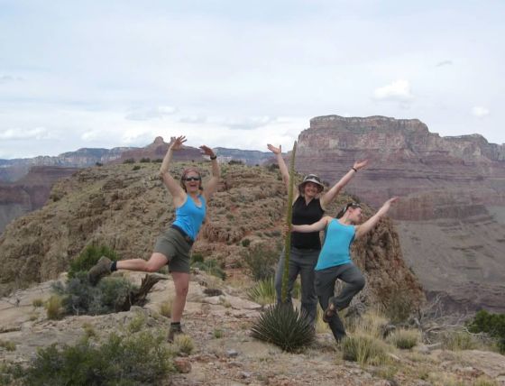
Women Backpacking the Wonders of the Grand Canyon, Arizona
Sierra Club Outings Trip | Backpack
Highlights
Includes
Overview
The Trip
PLEASE NOTE: Because of Grand Canyon National Park rules, a backcountry permit cannot be applied for until November 1, 2015. Dates and/or itinerary may have to be changed to obtain a permit. Final dates and itinerary should be solidified by mid-November 2015.
Want to backpack in the Grand Canyon, but worry it’s too hard? Looking for an introduction to hiking the Grand Canyon? During our trek, we will experience the wonders of the Grand Canyon and learn skills unique for traveling through this beautiful landscape. Our route along the Tonto between Grandview and South Kaibab trails includes sweeping vistas, dramatic views of the Inner Gorge, trickling streams, and colorful sunsets.
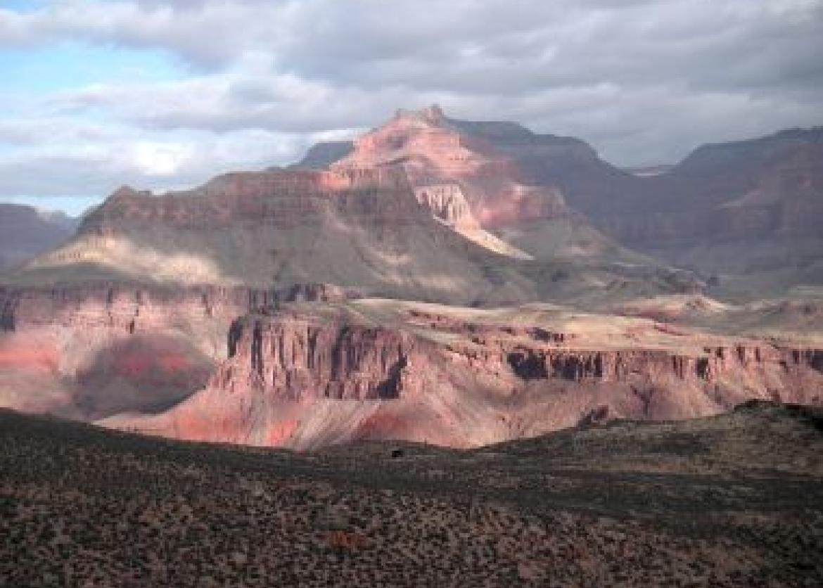
Join other adventuresome women on this six-day, five-night backpack trip through the challenging, inspiring, and empowering Grand Canyon, rightfully one of the World’s Seven Natural Wonders. The canyon may seem impressive when viewed from the rims. However, not until you drop below the rim, explore the less traveled areas, experience a sunrise and sunset from the depths of the canyon, gaze at the constellations, hear the hooting of owls nesting in the Coconino Layer, smell the wildflowers freshly in bloom, and hike back out will you truly experience the magic and magnitude of this incredible canyon.
Over 4.5 million people visit the South Rim each year, but only two percent dare to enter the Canyon’s depths and spend the night. These are the lucky ones. Nearly two billion years of the planet’s history is exposed in the Canyon’s layers. During our trip through the Canyon, we will explore and experience the geological history of the canyon while admiring the animals and plants that live in this challenging environment and the leader will share her knowledge of backpacking in the Canyon.
The demands of the trip require very good physical conditioning and mental stamina. A flexible attitude and a sense of adventure are helpful and necessary traits as well.
Itinerary
During our adventure we will cover approximately 30 miles on trail and an optional handful of miles off trail. Our trail crosses a number of drainages in which we will spend some time exploring: Cottenwood, Grapevine, Lonetree, and Cremation.
Distance covered each day will range from 4 to 9 miles. However, miles in the canyon do not tell the full story. Water is a scarce resource, thus many days will require carrying the weight of three to five liters of water. Our pace will range from slow to moderate, in keeping with our priority to have time to appreciate and relish the beautiful country through which we will pass. As time permits, participants may explore side canyons, search for wildlife, listen to the roaring Colorado River, take photographs, or simply stay in camp to relax, read, or write
During our adventure we will cover approximately 30 miles on trail and an optional handful of miles off trail. Our trail crosses a number of drainages in which we will spend some time exploring: Cottenwood, Grapevine, Lonetree, and Cremation.
Distance covered each day will range from 4 to 9 miles. However, miles in the canyon do not tell the full story. Water is a scarce resource, thus many days will require carrying the weight of three to five liters of water. Our pace will range from slow to moderate, in keeping with our priority to have time to appreciate and relish the beautiful country through which we will pass. As time permits, participants may explore side canyons, search for wildlife, listen to the roaring Colorado River, take photographs, or simply stay in camp to relax, read, or write.
On a typical day, we will rise at 6:30 a.m., dine on a hearty breakfast, break camp, and be hiking by 8:30 a.m. We will strive to be at camp by mid-afternoon with time to erect tents and clean up a little before dinner. However, some days may be long, meaning we may not get to camp until 5:00 p.m. or possibly later.
The following is our itinerary for the week. Consider it approximate as weather, the group’s pace, and the National Park Service’s permitting requirements may necessitate modifications.
Day 1: The official start of our trip is at 7 p.m. on Sunday March 27, 2016, at Maswik Lodge in the Grand Canyon Village on the South Rim of the Grand Canyon. We will discuss some basics about the outing and distribute the commissary. (Lodging and dinner not included.)
Day 2: We will meet at the Maswik lobby at 7 a.m. to caravan to our trailhead at Grandview, leaving a couple of cars near our exit trailhead. The first mile down through the Kaibab and Coconino layers drops 1,200 feet. We will use a slower pace, allowing everyone to get comfortable with the trail conditions while carrying heavy packs. The next two miles are more gradual yet still challenging (with a 1,300-foot descent) and bring us to Horseshoe Mesa. Time permitting, we’ll spend a few hours on the Mesa exploring the vast caverns of the Cave of the Domes and possibly hiking out one of the Mesa’s arms to get our first look into the Inner Gorge. Finally, we leave the Mesa, descending another 1,000 feet over a mile over loose rock and dirt, working our way into camp. In total today, we will hike approximately five miles. There is no water source after leaving Maswik Lodge until we reach camp, thus we will each have to carry three liters of water, increasing the weight of our packs at the start of the trip. (Breakfast not included.)
Day 3: We will move our camp a short distance, approximately four miles. After setting up camp, you will have many options: sit up high and meditate, write in your journal, climb some nearby rocks, observe and feel the Inner Gorge with both its silence and sounds of the Colorado River below, or, for the more adventurous, explore one of two possible off-trail routes. As we will be at a dry camp this evening, we will each need to carry a minimum of five liters, adding to the weight of the packs. You will be well rewarded for those efforts!
Days 4-6: For the next three days, we will meander west along the Tonto Trail, admiring the impressive rock formations of Wotan’s Throne, Angel’s Gate, Howland’s Butte, Zoroaster’s Temple, and the Inner Gorge, exploring up and down the side canyons for wildlife, wildflowers, and gurgling streams. We will have two short days, under five miles on each, allowing us to do day hikes down Grapevine and Lonetree. Our day from Grapevine to Lonetree includes just under nine miles on the trail. There is no water source at our last night’s camp, meaning we will once again have to carry extra water, increasing the weight of our packs for part of a day.
Day 7: We will have a challenging day today as we travel approximately 8 miles, with the last 4.5 miles climbing 3,300 feet. The total ascent today is closer to 3,700 feet.
Logistics
Getting There
The Grand Canyon National Park Service maintains a thorough webpage containing information about getting to the South Rim (http://www.nps.gov/grca/planyourvisit/directions_s_rim.htm). The nearest major airports are Phoenix (230 miles) and Las Vegas (275 miles). Flagstaff, AZ has a regional airport with limited flights. Shuttle service is available from Phoenix to the Grand Canyon Village via Flagstaff, AZ (http://www.arizonashuttle.com/flagstaff-reservations). Amtrak goes through Flagstaff. Alternatively, one may rent a car. Carpooling is strongly encouraged and the leader will provide a list of participants so carpools can be arranged. Please do not make non-refundable travel arrangements until notified to do so by the
Getting There
The Grand Canyon National Park Service maintains a thorough webpage containing information about getting to the South Rim (http://www.nps.gov/grca/planyourvisit/directions_s_rim.htm). The nearest major airports are Phoenix (230 miles) and Las Vegas (275 miles). Flagstaff, AZ has a regional airport with limited flights. Shuttle service is available from Phoenix to the Grand Canyon Village via Flagstaff, AZ (http://www.arizonashuttle.com/flagstaff-reservations). Amtrak goes through Flagstaff. Alternatively, one may rent a car. Carpooling is strongly encouraged and the leader will provide a list of participants so carpools can be arranged. Please do not make non-refundable travel arrangements until notified to do so by the trip leader.
Accommodations and Food
Meals (including beverages) will be provided from lunch on day two through lunch the last day of the outing. Responsibility for cooking and cleanup will be shared by trip participants. Breakfasts, lunches, and dinners will all be hearty, healthy, and varying. The leaders work hard to make the weight of the food as light as possible to lessen the loads in our packs. Careful attention is paid to ensuring there are sufficient calories with high-protein content so our bodies are well fueled. Homemade and organic foods are used as much as possible. We can easily accommodate vegetarians. In addition, water treatment will be provided.
Trip Difficulty
This trip is rated level 3 on a scale of 1 to 5, has areas of exposure requiring a good sense of balance, has limited access to water thus requiring heavier loads to carry, and has some very steep sections to descend and ascend alongside those challenges. This trip is designed for experienced backpackers interested in an introduction to backpacking the Grand Canyon.
Over the course of the week, we will gain and lose 4,000 feet. Most of the downhill will be on our first day and most of the uphill will be on our last day. However, the Tonto Trail undulates along its westward track, sometimes gaining/losing several hundred feet as it crosses each major side canyon. Additional miles and elevation gain/loss are possible on optional day hikes. In some places, the Grandview and Tonto trails get close to steep edges. People fearful of heights may not be comfortable through these exposed sections. The first mile and last mile of this outing may be on snow-packed or icy trails. If so, foot traction and walking sticks will be required.
The Grand Canyon is unique in that we will go down, down, down for the entire first day. While we will move at a gentle pace, knees must be prepared for the steady descent under a full pack and extra water. Total pack weight may start at as much as 40 pounds. Those with ultra-light gear could experience a more comfortable weight of approximately 35 pounds or less.
The leader requires that personal gear weigh no more than 20 pounds, which could require an investment in equipment upgrades and/or a willingness to travel with less (i.e. use of point and shoot camera over SLR). To fully participate and enjoy this trip, you must commit to a regular aerobic training program and hike with pack weight for the two to three months prior to our trip. The leader will recommend several practical techniques to prepare for the outing.
Late March is usually an ideal time to be in the Canyon. Inside the Canyon, daytime high temperatures should be in the 70s; nighttime lows should be in the upper 40s. Rain and wind are possible although rarely persistent at this time of year. But remember that weather can be unusual!
Equipment and Clothing
The Sierra Club provides the cooking gear, food, water purification, and a first-aid kit to be used for emergencies only. You are responsible for everything else that you want/need. We divvy up the gear and food (including trail food) provided by the Club, which generally equates to approximately 12-13 pounds each at the start of the trip. Three liters of water will add another 7 pounds. Add to that your 20 or less pounds for your initial decent. In addition, you must make sure your backpack has enough capacity for the extra gear, which will be the size of approximately two one-gallon milk cartons. With interest in making sure this is an enjoyable trip for everyone, the packs will be weighed at the trailhead. Prior to the trip, the leader will work with you to achieve this weight limit.
The leader will provide an extensive list of gear and a training program to each of the participants well in advance of the outing.
References
Maps:
- For an overview of the Grand Canyon, the Trails Illustrated Grand Canyon National Park map is good. Available online from many sources.
- For an overview of the Grand Canyon National Park located to the east of Hermits Rest, a good map is Grand Canyon National Park Trails, available from www.amazon.com or at the Grand Canyon.
- For detailed coverage, the U.S.G.S. 7.5-minute topographical maps have all the detail. These are not required but are perfect for the map enthusiast. Our route will be along 2 quadrangles: Cape Royal and Phantom Ranch -- available from www.usgs.gov. As an alternative, a custom map can be purchased from www.mytopo.com. Upon request, leader will provide a link to such map.
Websites:
- The National Park Service maintains a website for each of the national parks. The website for the Grand Canyon is especially complete, up-to-date, modern (podcasts, webcams), and informative. Regularly visit www.nps.gov/grca for information or just to look around.
Books:
- Ranney, Wayne, Carving the Grand Canyon. A book on the theories of how the Grand Canyon has been formed.
- Kolb, Ellsworth L., Through the Grand Canyon. The account of brothers Ellsworth and Emery Kolb’s trip down the Green and Colorado Rivers in 1911-1912. Beautifully written prose depicting life 100 years ago.
- Butler, Elias and Tom Myers, Grand Obsession. A look at Harvey Butchart’s tireless pursuit to find routes from the Rim to River in the Grand Canyon.
- Fletcher, Colin, The Man Who Walked Through Time. An account of Fletcher’s non-stop walk along the Colorado through the Grand Canyon.
Conservation
The real purpose of Sierra Club outings, which began in 1901, is to follow John Muir's example of bringing more people into the fold of protecting the earth's ecology. Muir wrote "if people could be got into the woods, even for once, to hear the trees speak for themselves, all difficulties in the way of forest preservation would vanish."
During our week in the wilds we will discuss and practice minimal impact techniques and take on minor tasks to erase the signs left behind by less knowledgeable campers.
The Grand Canyon National Park is not designated as a wilderness area. We will discuss what wilderness protection means, reasons for protecting more land as wilderness, and what can be done to improve this protection. We'll also discuss the importance of your involvement and how to relay your concerns about the protection of wild lands. Additionally, we will discuss current issues especially of importance to the Grand Canyon. You are encouraged to come prepared and introduce topics of interest to you.
Sierra Club National Outings is an equal-opportunity provider and will operate under a permit from Grand Canyon National Park.
Staff
Photos
Important Notes
- Carbon Offsets
- Carpooling
- Electronic Billing and Forms
- Electronic Devices
- Equipment
- Essential Eligibility Criteria
- How to Apply for a Trip
- Leader Gratuities
- Medical Issues
- Non-discrimination Statement
- Participant Agreement
- Seller of Travel Disclosure
- Single Supplements
- Terms and Conditions
- Travel Insurance
- Trip Feedback
- Trip Price
- Wilderness Manners