Adventure High in Wyoming's Wind River Mountains
Sierra Club Outings Trip | Backpack
Highlights
- Backpack along trails with views of mountain peaks
- Explore valleys with alpine lakes and rushing streams
- Enjoy a myriad of blooming wildflowers
Includes
-
Camaraderie and adventure with other passionate people
-
Tasty and varied lightweight meals
-
Experienced leaders, permits, and backcountry guidance
Overview
The Trip
"Thousands of tired, nerve-shaken, over-civilized people are beginning to find out that going to the mountains is going home; that wildness is a necessity; and that mountain parks and reservations are useful not only as fountains of timber and irrigating rivers, but as fountains of life." - John Muir
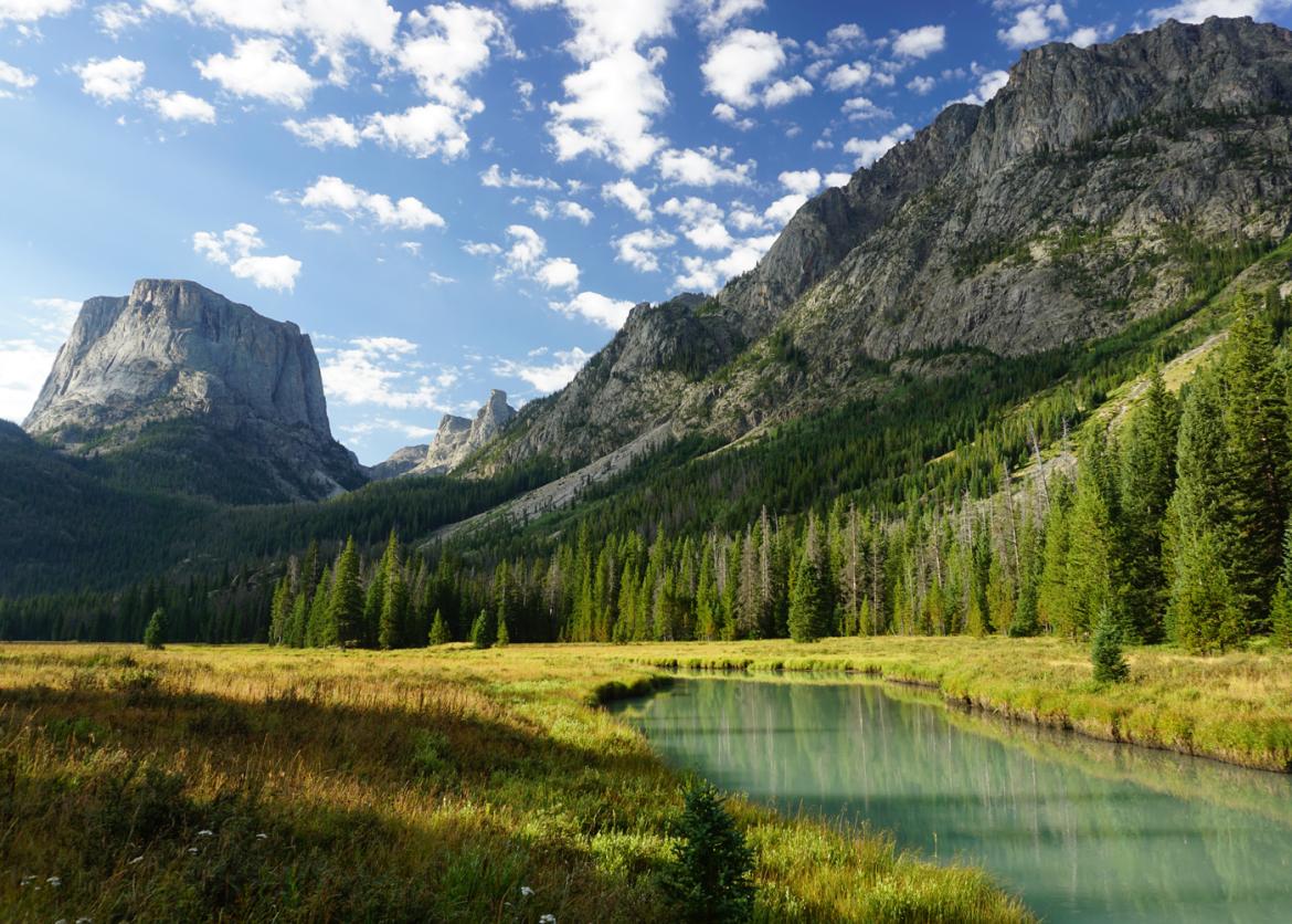
Wyoming's Wind River Range offers an unparalleled wilderness experience. Join other adventuresome backpackers on a week-long backpack through glacier-carved valleys with dozens of crystal-clear lakes and countless snowmelt cascades and streams. Alpine forests, rolling green meadows accented with vibrant wildflowers, and extraordinary mountain views are the backdrop for this spectacular hike
The Trip
"Thousands of tired, nerve-shaken, over-civilized people are beginning to find out that going to the mountains is going home; that wildness is a necessity; and that mountain parks and reservations are useful not only as fountains of timber and irrigating rivers, but as fountains of life." - John Muir
Wyoming's Wind River Range offers an unparalleled wilderness experience. Join other adventuresome backpackers on a week-long backpack through glacier-carved valleys with dozens of crystal-clear lakes and countless snowmelt cascades and streams. Alpine forests, rolling green meadows accented with vibrant wildflowers, and extraordinary mountain views are the backdrop for this spectacular hike. Highlights of the trip include hiking to the top of Squaretop Mountain, Stroud or Elbow peak, Knapsack Col (depending on weather, etc.), and Glover Peak (depending on time and weather).
The Wind River Range runs roughly northwest to southeast for 100 miles with the northern portion close to Grand Teton National Park. With the Continental Divide passing through the range, it is not surprising that numerous peaks higher than 13,000 and the highest peak in Wyoming -- Gannett Peak at 13,809 feet -- are located within the Winds.
The Winds are primarily granite, which have been carved into their present shape by glaciers -- glaciers that left behind valleys and cirques that today are filled with flowing streams and refreshingly frigid lakes. In summer, meadows in the valleys explode with blooming flowers in a myriad of colors enhanced by grey granite, blue sky, and white snow pack or fluffy clouds.
When below tree line, we will be in forests of pine, fir, and spruce. Fellow creatures of the woods include bear -- both black and grizzly -- elk, moose, deer, and the recently returning wolf. Watchful eyes can also spy soaring birds. Spending a week backpacking through and becoming a part of this primitive wilderness will revitalize and rejuvenate as only fresh air, starry nights, and long walks can.
Itinerary
Plan to meet at the Rivera Lodge in Pinedale, Wyoming at 4 p.m. on August 12 for introductions and distribution of commissary and equipment. It’s a great time to review trip plans and the packing list, and answer any last-minute questions.
Day 1: We get an early start for our caravan to Green Lakes Campground where our route begins and ends. Elevation is approximately 8,000 feet. The road to Green Lakes is in good shape and is a combination of paved and gravel roads that are passable by an ordinary sedan. After tightening our boots and hoisting our packs, we will be on our way, covering eight to nine miles and gaining almost 1,500 feet before reaching our creek-side camp
Plan to meet at the Rivera Lodge in Pinedale, Wyoming at 4 p.m. on August 12 for introductions and distribution of commissary and equipment. It’s a great time to review trip plans and the packing list, and answer any last-minute questions.
Day 1: We get an early start for our caravan to Green Lakes Campground where our route begins and ends. Elevation is approximately 8,000 feet. The road to Green Lakes is in good shape and is a combination of paved and gravel roads that are passable by an ordinary sedan. After tightening our boots and hoisting our packs, we will be on our way, covering eight to nine miles and gaining almost 1,500 feet before reaching our creek-side camp.
Day 2: For our second day on the trail, we will hike about six miles, ascending 2,400 feet and descending 1,200 feet, all on good trails. We will move from the forest and meadows to alpine country above tree line with dramatic views. We will cross a 10,000-foot pass before dropping down to a beautiful lake for our camp.
Day 3: Today we again hoist full backpacks for a day of on- and off-trail hiking with an optional side trip to the top of a tempting peak soaring over 12,000 feet. After covering three miles on-trail and three miles off-trail and gaining/losing 1,000 feet, we’ll come to our next home beside some unusually named lakes.
Day 4: We will spend the morning backpacking to our next camp, beside yet another pretty lake. This backpack is just five miles with less than 1,000 feet of ascent and descent. For those inclined, we will spend the afternoon scampering to the top of Stroud or Elbow Peak, another peak topping out above 12,000 feet. If the day is clear, we’ll see all the way to the Tetons.
Day 5: Depending on weather and other considerations, this morning we hike less than a mile before dropping our packs for a day hike to Knapsack Col, our lunch destination. From Knapsack Col we have spectacular vistas of the Continental Divide and the upper reaches of Titcomb Basin. After returning to our packs we will hike with packs for another four miles before setting up camp.
Day 6: Today we enjoy a mostly downhill hike, about seven miles with a loss of 2,500 feet.
Day 7: The top of Squaretop is our goal for the day. This will take us all day, but will be a grand finale to our week’s adventure. We will leave at first light to allow plenty of time to get to the top and look around. Along the way, we will pass a beautiful lake that we will enjoy on our return if time permits.
Day 8: On our last morning, we will again be hiking at first light to experience the beauty of the sun rising over the verdant Green River Valley and lighting Squaretop Mountain. We will hike nine miles back to our cars at Green Lakes Campground, arriving around noon. After caravanning back to Pinedale, we will share a well-deserved celebratory lunch at a local cafe.
Please note that the itinerary may have to be changed depending on weather, the strength of the group, campsite availability, and trail conditions.
Logistics
Getting There
The closest major airport is in Salt Lake City. It is about a five-hour drive to Pinedale from Salt Lake. There are regional flights available to the airport in Jackson, Wyoming, which is just a two-hour drive from Pinedale, but these can be expensive and are subject to local weather. Carpooling is strongly encouraged and the leader will provide a list of participants so carpools can be arranged.
Pinedale is a reasonable-sized town with several lodging choices and restaurants, some grocery stores, a complete outdoor gear shop for any last-minute needs, and an exceptionally good public library complete with internet access
Getting There
The closest major airport is in Salt Lake City. It is about a five-hour drive to Pinedale from Salt Lake. There are regional flights available to the airport in Jackson, Wyoming, which is just a two-hour drive from Pinedale, but these can be expensive and are subject to local weather. Carpooling is strongly encouraged and the leader will provide a list of participants so carpools can be arranged.
Pinedale is a reasonable-sized town with several lodging choices and restaurants, some grocery stores, a complete outdoor gear shop for any last-minute needs, and an exceptionally good public library complete with internet access.
Please do not make non-refundable travel arrangements until notified to do so by the trip leader.
Accommodations and Food
All meals are included from lunch on the first day of the outing through lunch on the last day (unless everyone wants to lunch in Pinedale). Everyone shares in meal preparation and cooking chores, including cleanup. Meals include hearty, healthy, and varying breakfasts, lunches, and dinners. The leaders work hard to make the weight of the food as light as possible to lessen the loads in our packs. Careful attention is paid to ensuring that our meals contain sufficient calories with high protein content so our bodies are well fueled. Organic foods are used as much as possible. We can easily accommodate vegetarians.
Trip Difficulty
This trip is rated level 4 on a scale of 1 to 5. Our route is mostly on-trail and is rated 4 (moderately strenuous) because of elevation gains and losses, although there will be rugged sections that will feel more like a level 5. The entire route is about 45 miles, 40 on-trail and about five cross-country. Nearly every day there will be a day hike, usually up a peak, and these day hikes will add considerably to the mileage. But each day hike is optional.
Summer weather is often sunny and pleasant, but we may contend with rain, hail, sleet, thunderstorms, and even the possibility of snow at higher elevations. Days are usually mild, about 70 degrees at this time of year, and evening temperatures can drop into the lower 30s occasionally. Mosquitoes can be challenging, depending on the seasonal snowpack and runoff. Backpacking is by nature a strenuous activity with unexpected challenges. To tolerate the high altitude and fully enjoy this experience, you must commit to a regular aerobic training program with pack weight for the three months prior to our trip. The leader will recommend several practical techniques to prepare for the outing.
Equipment and Clothing
Sierra Club provides the cooking gear, food, water purification, and a first-aid kit (which is used only for emergencies). We will distribute 12-13 pounds of group food and gear for each participant to carry, and the food will be in bear cans. We strongly discourage anyone from bringing an overloaded pack. This trip will be much more enjoyable if you keep your pack weight to a minimum (personal gear below 25 pounds, if not lower). We will work with everyone to pack light since the trip will be safer and easier if everyone keeps his or her pack weight to the minimum. Pre-trip correspondence will provide a comprehensive gear list along with recommendations.
References
Maps:
- Northern Wind River Range, Hiking Map & Guide. Earthwalk Press. This map provides an overview of the entire northern section of the Winds. Leaders will carry one copy of this on the trip for all to peruse.
- USGS 7.5-minute maps: Green River Lakes, Gannett Peak, and Square Top Mountain. These topographic maps are for the map enthusiast. Leaders will carry one set of these on the trip for all to peruse.
Books:
- Woods, Rebecca, Walking the Winds. Considered to be one of the basic guidebooks for the Winds.
- Kelsey, Joe, Wyoming’s Wind River Range. An excellent introduction to the area.
- Kelsey, Joe, Climbing and Hiking the Wind River Mountains. Comprehensive guide to trails, routes, and climbs in the Wind River Range.
- Kershaw, Linda, Plants of the Rocky Mountains. Detailed field guide to the flowers and trees of the Winds and all of the Rocky Mountains.
- DeLella Benedict, Audrey, The Naturalist’s Guide to the Southern Rockies. Introduction to the ecology of the Rocky Mountains.
Website:
Conservation
We will discuss the devastation that the Pine Bark Beetle and Blister Rust are causing to lodgepole pines and whitebark pines in the western mountains, and how climate change may be part of the cause. The Bridger Wilderness area is permanently protected by Congress, but most of Wyoming's roadless areas have no such legal protection, and logging, drilling, and off-road vehicles continue to threaten them. We will discuss what wilderness protection means, reasons for protecting more land as wilderness, and the Wilderness Act itself. We'll also discuss returning wolves to some of the areas where they were eliminated in the last century, such as Yellowstone and New Mexico.
Sierra Club National Outings is an equal-opportunity provider and will operate under a permit from the Bridger-Teton National Forest.
Staff


Important Notes
- Carbon Offsets
- Carpooling
- Electronic Billing and Forms
- Electronic Devices
- Equipment
- Essential Eligibility Criteria
- How to Apply for a Trip
- Leader Gratuities
- Medical Issues
- Non-discrimination Statement
- Participant Agreement
- Seller of Travel Disclosure
- Single Supplements
- Terms and Conditions
- Travel Insurance
- Trip Feedback
- Trip Price
- Wilderness Manners