Hopkins Basin and the Mono High Country, John Muir Wilderness, California
Sierra Club Outings Trip | Backpack
Highlights
- Hike a spectacular high route to Hopkins Basin
- Enjoy the camaraderie of a shared adventure
- Explore or relax on a planned layover day
Includes
-
All planning and permits for a High Sierra trek
-
Great meals for vegetarians and non-vegetarians alike
-
Shared group cooking gear and commissary equipment
Overview
The Trip
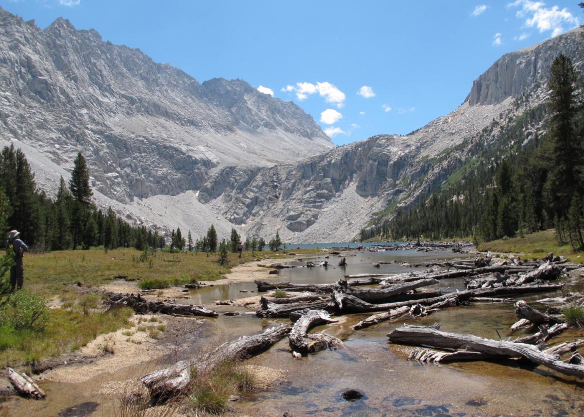
If you’ve always wanted to backpack the Sierra Nevada, but you can’t afford to spend a full week doing it, then this could be the trip you are looking for. We’ll meet at a campground near Mammoth Lakes, CA, which can be reached by public transit from the Reno, NV airport. We’ll hike five days, enjoying a variety of the Sierra’s finest scenery on our backpacking adventure into the Sierra high country. Scenic highlights include 13,000-foot Red Slate Mountain, remote and secluded Hopkins Basin, the glacially carved Mono Recesses, and spectacular Little Lakes Valley.
Our hike starts a few miles south of Mammoth Lakes at McGee Creek. We’ll travel most days on well-maintained trails, but portions of our journey will be on secondary trails or -- for a good part of one day -- completely off trail. Our route includes two crossings of the Sierra Crest, both over 11,000 feet and one completely off trail
The Trip
If you’ve always wanted to backpack the Sierra Nevada, but you can’t afford to spend a full week doing it, then this could be the trip you are looking for. We’ll meet at a campground near Mammoth Lakes, CA, which can be reached by public transit from the Reno, NV airport. We’ll hike five days, enjoying a variety of the Sierra’s finest scenery on our backpacking adventure into the Sierra high country. Scenic highlights include 13,000-foot Red Slate Mountain, remote and secluded Hopkins Basin, the glacially carved Mono Recesses, and spectacular Little Lakes Valley.
Our hike starts a few miles south of Mammoth Lakes at McGee Creek. We’ll travel most days on well-maintained trails, but portions of our journey will be on secondary trails or -- for a good part of one day -- completely off trail. Our route includes two crossings of the Sierra Crest, both over 11,000 feet and one completely off trail. All but the first mile of our trip and the last will be in the John Muir Wilderness.
The off trail portion of the trip includes some hiking on rough terrain with loose footing. Such hiking can be tiring and demanding. Good balance and a patient, tolerant attitude are required for the trip.
Our goal is to be in camp by mid-to-late afternoon -- say by 3:00 or 4:00 p.m. -- most days to allow time before dinner to explore or swim or perhaps just to find a quiet place to relax and take in the scenery. We also plan to take one layover day. Each camp will be above 10,500 feet, and each will provide a wondrous view.
Join us if you are looking for a trip that consists of fewer days than most of our offerings, but that still includes spectacular scenery and adventurous hiking! Please read the full trip description before signing up, and contact the leader if you have additional questions.
Itinerary
Our hiking schedule is not rigid. How far we get each day and where we camp depends on how we feel, the weather, and other factors outside of our control. Likewise, our precise route is not rigidly set since we will be hiking off trail for a portion of the trip. Flexibility is important. The itinerary described here should be taken as a general plan, and the actual route and schedule may well depart from this plan.
Day 1: The trip will begin with a potluck dinner at 5:00 p.m. on Sunday at a campground near McGee Creek trailhead and 33 miles from Bishop, California on the eastern side of the High Sierra. The evening will be a great time for us to meet our backpacking companions and relax over a meal together before beginning our adventure. We will also go over trip procedures, give ourselves one more night to acclimate to the high elevation and finish preparations for our journey
Our hiking schedule is not rigid. How far we get each day and where we camp depends on how we feel, the weather, and other factors outside of our control. Likewise, our precise route is not rigidly set since we will be hiking off trail for a portion of the trip. Flexibility is important. The itinerary described here should be taken as a general plan, and the actual route and schedule may well depart from this plan.
Day 1: The trip will begin with a potluck dinner at 5:00 p.m. on Sunday at a campground near McGee Creek trailhead and 33 miles from Bishop, California on the eastern side of the High Sierra. The evening will be a great time for us to meet our backpacking companions and relax over a meal together before beginning our adventure. We will also go over trip procedures, give ourselves one more night to acclimate to the high elevation and finish preparations for our journey.
Several of us will arrive earlier in the afternoon to shuttle a few vehicles to our exit trailhead at Rock Creek, approximately 17 miles from our campground.
Although the trip begins on Sunday evening, we encourage participants to arrive a day or two early to begin acclimatizing to the high elevations we will encounter during the trip. Giving your body an extra couple of days to adjust to the high elevation can often make a big difference between enjoying the trip or merely just enduring it.
Day 2: We will serve a group breakfast at a campground a few miles from our entry trailhead. Following breakfast, we will drive to the McGee Creek trailhead (7,900 feet) to begin our hike.
This day we plan to cover about seven miles and climb about 2,600 feet to our camp at Big McGee Lake (10,500 feet). We will have our heaviest packs of the trip and we won’t be fully acclimated to the altitude, which will make this one of the more difficult days.
Days 3-4: We will have some flexibility where to take our layover day, depending on conditions and our progress. Our first option will be to take the layover at Big McGee Lake, from which we can continue on trail to McGee Pass and climb 13,163-foot Red Slate Mountain to see spectacular views of surrounding red-hued peaks. An alternate day hike from Big McGee Lake would head off trail to Corridor Pass, which connects to Convict Creek and Convict Lake.
On our second moving day -- either before or after the layover -- we will climb steeply off trail from Big McGee Lake and cross the Sierra Crest at 11,400-foot Hopkins Pass, our entry to Hopkins Basin. Years ago, a maintained trail showed the way, but today we will see only faint signs of this old path -- for the most part we will be completely off trail. From the pass, we’ll descend relatively gradually to our camp near Hopkins Creek.
If we have not taken our layover day at Big McGee Lake, we will do so here in Hopkins Basin. Hiking opportunities include exploring this remote basin and neighboring ridges and peaks.
Day 5: We’ll descend a secondary trail to Mono Creek, where we return to maintained trails. We’ll hike upstream to Trail Lakes, where we’ll make our last camp on ledges overlooking one of the lower lakes. If we are making good progress, along the way we will divert to have lunch in spectacular Fourth Recess.
Day 6: On the last day we take the trail over 12,000-foot Mono Pass and descend into Little Lakes Valley, which Galen Rowell famously called “the prettiest place on earth.” During our descent, we’ll enjoy spectacular views of 13,000-foot peaks surrounding the Valley, including Mt. Dade, Mt. Abbot, and Bear Creek Spire. A short hike down-valley brings us to the Rock Creek Road and the end of our adventure.
Logistics
Getting There
We will meet at a campground near the McGee Creek trailhead, which is about 10 miles south of the town of Mammoth Lakes on the eastern side of the Sierra Nevada. The closest major airport is in Reno, about 180 miles to the north. A small regional airport serves Mammoth Lakes directly, though service may be infrequent and less economical. Airports in the San Francisco and Los Angeles areas are about 270 miles and 300 miles from McGee Creek, respectively. Las Vegas is also about 300 miles away.
Trip members flying from other parts of the country should consider sharing a rental car or arranging rides from one of these airports. As of this writing, Eastern Sierra Transit offers bus service from the Reno airport to Mammoth Lakes on Monday, Tuesday, Thursday, and Friday. Please check online for current information
Getting There
We will meet at a campground near the McGee Creek trailhead, which is about 10 miles south of the town of Mammoth Lakes on the eastern side of the Sierra Nevada. The closest major airport is in Reno, about 180 miles to the north. A small regional airport serves Mammoth Lakes directly, though service may be infrequent and less economical. Airports in the San Francisco and Los Angeles areas are about 270 miles and 300 miles from McGee Creek, respectively. Las Vegas is also about 300 miles away.
Trip members flying from other parts of the country should consider sharing a rental car or arranging rides from one of these airports. As of this writing, Eastern Sierra Transit offers bus service from the Reno airport to Mammoth Lakes on Monday, Tuesday, Thursday, and Friday. Please check online for current information.
We will send a trip roster to all participants well before the trip in order to help facilitate ride sharing. Specific driving directions will also be sent before departure.
Please do not make non-refundable travel arrangements until notified to do so by the trip leader.
Accommodations and Food
We will plan a diverse and appealing menu to accommodate both vegetarians and non-vegetarians. Responsibility for cooking will be shared among the trip members. Our first meal will be breakfast on the morning of Friday and our last meal will be lunch on our final hiking day, Tuesday.
Trip Difficulty
The overall difficulty of the trip is rated 4 on a scale from 1 to 5, where 1 denotes the least difficult and 5 the most difficult trips.
Altogether, we will hike about 25 miles, about 5 miles of which will be off trail. We plan to hike four to nine miles on travel days, and we intend to take one layover day. We will cross the Sierra Crest twice -- once on a maintained trail and once on an off trail cross-country route.
The off trail section of the trip includes some hiking on rough terrain with loose footing. Such sections can be tiring and demanding. Cross-country hiking requires good balance, stamina, and a patient, tolerant attitude, all of which are requirements for the trip.
Our greatest daily elevation gain is on the first day, when we will ascend 2,600 feet to Big McGee Lake. The total elevation gain summed over four planned moving days will be about 6,100 feet. Our greatest elevation loss will be on the final day, when we descend 1,800 feet.
The high elevation of this hike also contributes to the overall difficulty. We will reach an elevation of 10,500 feet on the first day. All of our planned camps will be at this elevation or above, including one at 11,200 feet. In years with high snowfall, late-melting snow on the high passes may also make hiking more difficult.
Participation in this outing requires that you be experienced, in shape, and have reasonable expectations for the trip. Very good aerobic conditioning is essential.
Our objectives are to enjoy some spectacular country and to complete the trip safely as a group.
Equipment and Clothing
A list of suggested personal equipment will be sent to all participants. If you would like the list before signing up, let the leader know and they will send you a copy. Each person should keep the weight of personal gear to 20 pounds or less so that -- with the addition of approximately 10 to 12 pounds of commissary supplies and two or more pounds of water -- total pack weight will be no greater than 40 pounds at the start.
We will provide all food and cooking equipment, but you must bring your own cup, bowl, and eating utensils. Some of the group equipment is relatively bulky, particularly pot sets and bear canisters. Your pack should be sufficiently large to carry an item about the size of a full paper grocery bag (alternatively, four or five one-gallon milk jugs) in addition to your personal gear.
Although Sierra summers are generally relatively dry, you still must be prepared for rain. For shelter, tents are strongly encouraged, and lightweight waterproof tarps are the required minimum. Where possible, we will help participants contact other trip members who want to share shelters. For clothing, you should bring a waterproof jacket and rain pants rather than a poncho.
References
Please plan on bringing your own map and compass. Not only is this a matter of safety, but you will have a better appreciation of where we are going and where we have been.
Maps covering our route include:
- Three USGS 7.5-minute quadrangles -- Convict Lake, Mt. Abbot, and Mt. Morgan.
- The combined Mammoth High Country and Mono Divide High Country maps published by Tom Harrison Maps (www.tomharrisonmaps.com). (The first of these -- Mammoth High Country -- would be used only while on trail the first two days; a photocopy of this section of trail would likely suffice.)
- The two-sheet map set for the John Muir Wilderness and Sequoia/Kings Canyon Wilderness published by the U.S. Forest Service.
- Secor, R.J., The High Sierra: Peaks, Passes, and Trails. The Mountaineers. An excellent general reference to trails, cross-country routes, and climbing routes in the Sierra Nevada.
- Laws, John Muir, The Laws Field Guide to the Sierra Nevada. Heyday Books. An excellent field guide to the plants and wildlife of the Sierra.
Conservation
The Sierra Club is an environmentally focused entity. We are concerned about conservation and sustainability of resources, both locally and globally. Our work is accomplished by volunteers and aided by a salaried staff, encouraging grassroots involvement. Our outings seek to empower participants toward greater understanding, advocacy, and participation in the goals of the club.
The Wilderness Act of 1964 defines wilderness as “an area where the earth and its community are untrammeled by man, where man himself is a visitor.” This important act first established the National Wilderness Preservation System, originally protecting nine million acres of national forest lands. Today some 106 million acres are encompassed by the system, including the John Muir Wilderness, where we will be visitors during our five-day trip.
Although this wilderness is now protected from logging and mining activities, this has not always been the case. Furthermore, much of the surrounding public lands still do not receive the same level of protection. We will examine and consider the level of protection that wilderness designation provides, appreciate how this land compares with other types of protected areas we are familiar with, and discuss how we should protect these areas for future generations. This outing also provides an excellent opportunity to consider the impact our own excursion has upon the land.
Sierra Club National Outings is an equal-opportunity provider and when applicable will operate under permits obtained from U.S. federal land agencies.
Staff


Important Notes
- Carbon Offsets
- Carpooling
- Electronic Billing and Forms
- Electronic Devices
- Equipment
- Essential Eligibility Criteria
- How to Apply for a Trip
- Leader Gratuities
- Medical Issues
- Non-discrimination Statement
- Participant Agreement
- Seller of Travel Disclosure
- Single Supplements
- Terms and Conditions
- Travel Insurance
- Trip Feedback
- Trip Price
- Wilderness Manners