Traversing the Jewels of the Grand Canyon, Arizona
Sierra Club Outings Trip | Backpack
Highlights
Includes
Overview
The Trip
A backcountry permit cannot be applied for until November 1, 2015 because of Grand Canyon National Park rules. Trip dates may have to be changed or the itinerary altered to obtain the needed permit. The permit will be obtained by about mid-November, and the dates and itinerary will be solidified at that time
The Trip
A backcountry permit cannot be applied for until November 1, 2015 because of Grand Canyon National Park rules. Trip dates may have to be changed or the itinerary altered to obtain the needed permit. The permit will be obtained by about mid-November, and the dates and itinerary will be solidified at that time.
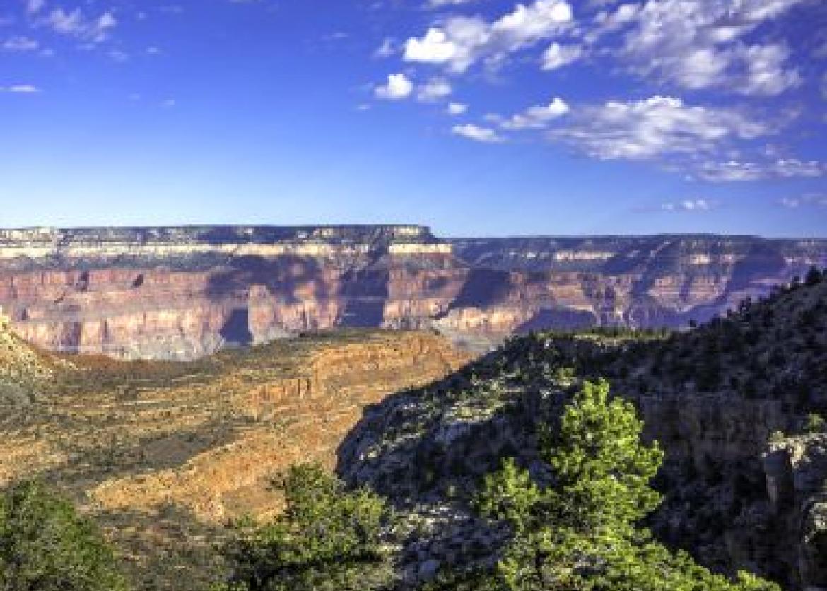
About 13,000 years ago, humans made their first impressions in the Grand Canyon area. The first Europeans, García López de Cárdenas and his men, first glimpsed the Canyon from the South Rim in 1540. John Wesley Powell's exploration of the Colorado River in 1869 led prospectors, railroad men, and promoters (like William Bass) to dream of ways to turn the wonders of the Grand Canyon into personal fortunes. Yet not until after World War II did tourists and hikers began to seek out the area's beauty and solitude. Harvey Butchart with his family came to Flagstaff during the postwar period to teach mathematics at Northern Arizona University. Intrepid backcountry hikers like us are indebted to him for the 40 years he spent exploring and writing about the backcountry of this fabulous place in his free time.
The Bass Trail is named for William Wallace Bass, who developed the trail around 1887 to take tourists to the beautiful, yet remote, North Rim from the train depot at Williams or Ash Fork. Tourists from the 1800s would enjoy a two- or three-week pack trip with Bass down the South Bass Trail, crossing the Colorado on a cable ferry. We will use the historic South Bass Trail as our entrance into the Canyon. Turning east at the Tonto platform, about 1,500 feet above the Colorado, we’ll use the Tonto Trail as we snake our way through numerous side canyons named for different jewels. The Tonto Trail was never built by anyone, but has been in use for probably thousands of years, as the easily eroded Bright Angel Shale created a relatively flat bench, which Native Americans used to traverse the inner Canyon. We’ll eventually come to Boucher Canyon, named after Louis Boucher from Quebec, Canada, who came to the Canyon in the late 1800s to prospect. He built the Silver Bell Trail to Dripping Springs, from the South Rim, where he also built a cabin. Then he extended the trail through Long Canyon (renamed Boucher Canyon) to the Colorado. He established a copper mine and several cabins and maintained a garden and orchard about a mile from the Colorado. Our exit from the Canyon will be along the trail Boucher built, which was eventually named in his honor.
The geology of the Grand Canyon is appreciated around the world. Our journey will take us through the young Kaibab limestone (~250 million years old), Toroweap, Hermit Shale, Supai Group, Redwall Limestone, Muav Limestone, Bright Angel Shale, Tapeats sandstone all the way to the ancient Vishnu Schist (~1.8 billion years old). These rock formations cover a third of our planet’s history. The formation of the Grand Canyon is still not completely understood, but likely involved headward erosion, a dramatic stream capture of an ancient Little Colorado (flowing in the opposite direction), catastrophic spillover, karst collapse, and other geologic forces. Although six million years is often cited as the age of the Canyon, there are still some geologists who think the Canyon might be as old as 70 million years.
The weather is usually dry this time of year, but rain and even snow is possible. Usually warm during the day (80s) and cooler at night (60s), the weather could be ideal. However, Canyon weather can vary significantly, and be hotter, colder, windier, and wetter than expected.
Itinerary
Day 1: We will meet early at the Backcountry Visitor Center for a shuttle that will take us to the S. Bass Trailhead. The drive will take about two hours. After a short trailhead talk, we will start down the S. Bass Trail. Enjoying this historic trail, we will wind our way down to the Tonto Trail, arriving a little after noon. Those interested will day hike to the South Bass Beach at the Colorado River and back. Later in the afternoon, we will hike a mile to the east along the Tonto Trail where we will camp for our first night on a wide expanse of the Tonto Plateau. We will cover about seven miles with packs and descend about 3,500 feet. The hike to the Colorado River and back will add an additional 3.5 miles and 1,000 feet lost and regained
Day 1: We will meet early at the Backcountry Visitor Center for a shuttle that will take us to the S. Bass Trailhead. The drive will take about two hours. After a short trailhead talk, we will start down the S. Bass Trail. Enjoying this historic trail, we will wind our way down to the Tonto Trail, arriving a little after noon. Those interested will day hike to the South Bass Beach at the Colorado River and back. Later in the afternoon, we will hike a mile to the east along the Tonto Trail where we will camp for our first night on a wide expanse of the Tonto Plateau. We will cover about seven miles with packs and descend about 3,500 feet. The hike to the Colorado River and back will add an additional 3.5 miles and 1,000 feet lost and regained.
Day 2: Continuing east along the Tonto Trail, we will head to Serpentine, our first jewel side canyon. From Serpentine we cross Emerald and Quartz canyons before arriving at Ruby Canyon and our camp for the night. If time and energy allow, we might look for the route to the Colorado that exists from Ruby. Today we will hike about nine miles with packs along the sinuous Tonto.
Day 3: After traversing Jade and Jasper canyons, we will arrive at Turquoise Canyon, where we will likely have lunch. We will explore down Turquoise, looking for a grotto with some big pools to cool off in. Depending on circumstances, we will either camp at Turquoise Canyon or continue our journey in the afternoon to Sapphire Canyon. Today we hike about six to nine miles with packs along the undulating Tonto Trail, neither gaining nor losing much elevation.
Day 4: Depending on where we camped yesterday, we will hike six to nine miles across Agate Canyon to Slate Canyon, where we will camp for the night. If time permits, we may dayhike down Slate Canyon until we encounter a beautiful spot with a large obelisk and pour-off.
Day 5: This morning, we hike about five to six miles into Topaz Canyon and then to Boucher Canyon, setting up camp at the Colorado. We’ll enjoy a leisurely afternoon in this lovely area, watching the timeless Colorado go by.
Day 6: Today we will have a gorgeous, but challenging, hike up the Boucher Trail. We will be carrying at least six quarts of water as we will have a dry camp tonight, although we will have less commissary food and equipment since we are near the end of our hike. We will be ascending about 3,000 feet over six miles to Yuma Point, where we will camp for the night. Yuma Point has some of the most spectacular views in the Canyon.
Day 7: This morning we continue hiking up the Boucher Trail, where we will enjoy great views for a couple of miles and get to a place where we pause and drop our packs. From there, we will take a day hike of about a mile to one of the lovely oases in the Canyon called Dripping Springs, where Boucher built his first cabin. Returning to our packs, we will continue up the Boucher Trail, eventually connecting with the Hermit Trail, which will take us to Hermit Rest and the end of our journey. We will take the park shuttle back to the backcountry office and our cars, arriving around noon. Today we have hiked about six miles with packs, ascending about 2,000 feet.
Note: The exact itinerary for the trip may vary from what is described above depending on the weather, water availability, permit availability, and the strength and preferences of the group.
Logistics
Getting There
We will meet at the Backcountry Visitor Center on the South Rim at 5:00 p.m. on the day before our trip to have a trip briefing and to distribute commissary. The leaders will be staying at the Maswik Lodge. Make your lodging reservations promptly as this is a popular time of year at the Canyon: http://www.grandcanyonlodges.com/. Grand Canyon National Park is about 75 miles from Flagstaff, 180 miles from Phoenix, AZ, and 270 miles from Las Vegas, NV. Regular flights are available to all three airports. Ground shuttles are available from Flagstaff or Phoenix to Grand Canyon Village on the South Rim: http://www.arizonashuttle.com/. Please do not make non-refundable travel arrangements until notified to do so by the trip leader
Getting There
We will meet at the Backcountry Visitor Center on the South Rim at 5:00 p.m. on the day before our trip to have a trip briefing and to distribute commissary. The leaders will be staying at the Maswik Lodge. Make your lodging reservations promptly as this is a popular time of year at the Canyon: http://www.grandcanyonlodges.com/. Grand Canyon National Park is about 75 miles from Flagstaff, 180 miles from Phoenix, AZ, and 270 miles from Las Vegas, NV. Regular flights are available to all three airports. Ground shuttles are available from Flagstaff or Phoenix to Grand Canyon Village on the South Rim: http://www.arizonashuttle.com/. Please do not make non-refundable travel arrangements until notified to do so by the trip leader.
Accommodations and Food
Our first trip meal will be lunch on our first day and the last meal will be breakfast on our final morning. Responsibility for cooking and clean-up will be shared by trip participants. Meals include hearty, healthy, and varying breakfasts, lunches, and dinners. These meals are vegetarian with some optional meat available occasionally, such as jerky with some lunches. The leaders work hard to make the weight of the food as light as possible to lessen the loads in our packs. The leaders also use organic food as much as possible. Participants should bring their favorite snacks to supplement between meals. At the end of our trip, we hope everyone will be able to share a well-deserved lunch at a local restaurant.
Trip Difficulty
We cover approximately 45 miles with packs and have to descend and ascend 5,000 feet to get into the Canyon and back out. And in between there is plenty of more minor up and down hiking that will keep our heart rates up. Our average daily distance is about 6-7 miles on good trail. We will also do about 10 to 15 miles of dayhiking without packs during the week. This is in addition to the 45 miles with packs, but all the dayhiking is optional. Most of the hiking is straightforward, but there is arduous hiking as well. All backpack trips are physically demanding and Grand Canyon backpack trips can be especially demanding because of dramatic elevation changes, unstable footing, exposure to the sun, and potentially hot conditions. This trip is rated moderate to strenuous (4). There will be sections that feel more like a strenuous outing (Level 5) and stretches along the Tonto that feel more like a moderate hike (Level 3). Because of the rating, participants must be committed to seriously training for this outing for a minimum of two months and preferably three months prior to the start of the trip. The leaders will gladly share a training routine that has been successful for others on Grand Canyon trips.
Equipment and Clothing
The Sierra Club provides the cooking gear, food, water purification, and a first-aid kit to be used for emergencies only. You are responsible for everything else that you want/need. We divvy up the gear and food provided by the Club, which generally equates to approximately 11-12 pounds each at the start of the trip. Your backpack needs to have enough capacity for this extra gear, which will be the size of approximately two one-gallon milk cartons.
We strongly discourage anyone from bringing an overloaded pack. This trip will be much more enjoyable if you keep your pack weight to a minimum (personal gear below 20 pounds, if not lower). We will work with everyone to pack light since the trip will be safer and easier if everyone keeps his or her pack weight to the minimum. Pre-trip correspondence will provide a comprehensive gear list along with recommendations.
References
Maps:
- For an overview of the Grand Canyon, the Trails Illustrated Grand Canyon East: Grand Canyon National Park map is good. Available online from many sources.
- For detailed coverage, the U.S.G.S. 7.5-minute topographical maps have all the detail. These are not required but are perfect for the map enthusiast. Maps that cover our route include: Havasupai Point, Piute Point, and Grand Canyon, AZ. Leaders will carry a set of these on the trip and are happy to share.
Books:
- Fedarko, Kevin, Emerald Mile. 2013. An amazing and unique river adventure.
- Ranney, Wayne, Carving Grand Canyon. Grand Canyon Association, 2012. Read about how the Grand Canyon may have come into existence.
- Davis, Wade, River Notes: A Natural & Human History of the Colorado. Island Press, 2012. This is an excellent summary of how the once mighty and majestic Colorado became the dammed and highly regulated river that it is today.
- Osborne, Sophie A. H., Condors in Canyon Country: The Return of the California Condor to the Grand Canyon Region. Grand Canyon Association, 2008. An epic attempt to save a great bird.
- Price, L. Greer, An Introduction to Grand Canyon Geology. Grand Canyon Association, 1999. An accessible book with plenty of illustrations and photos about Grand Canyon geology.
- Anderson, Michael F., Living at the Edge. Grand Canyon Association, 1998. A book about the colorful pioneering people of European descent who first explored and settled in the Grand Canyon.
- Huisinga, Ann, Lori Makarick and Kate Watters, River and Desert Plants of the Grand Canyon. Mountain Press Publishing, 2006. A great reference for the common shrubs, trees, and flowers of the Inner Canyon.
Websites:
- The Grand Canyon Association is a great resource with many books of interest. Please visit http://www.grandcanyon.org/
- The National Park Service maintains a website for each national park. The website for the Grand Canyon is especially complete, up-to-date, modern (podcasts, webcams), and informative. Regularly visit www.nps.gov/grca for information or just to look around.
Conservation
There are numerous conservation issues regarding the Grand Canyon: the introduction of condors, noise from sightseeing aircraft, air quality over the park, uranium mining threats, control of the Colorado River by the Glen Canyon Dam, and visitor management (including backcountry use). However, the biggest issue is water use in the West by burgeoning cities such as Las Vegas, Phoenix, and Tucson. These cities largely depend on the Colorado River for their water and are running it dry. The Southwest is in the grips of a 15-year drought and water levels in Lake Mead and Lake Powell are roughly 50% of capacity and are at historic lows since they filled decades ago. In response, the Federal Government began cutting 10% of the water allotments in October of 2013 to the seven states that receive water from the Colorado, including Arizona.
Sierra Club National Outings is an equal-opportunity provider and will operate under a permit from Grand Canyon National Park.
Staff
Photos
Important Notes
- Carbon Offsets
- Carpooling
- Electronic Billing and Forms
- Electronic Devices
- Equipment
- Essential Eligibility Criteria
- How to Apply for a Trip
- Leader Gratuities
- Medical Issues
- Non-discrimination Statement
- Participant Agreement
- Seller of Travel Disclosure
- Single Supplements
- Terms and Conditions
- Travel Insurance
- Trip Feedback
- Trip Price
- Wilderness Manners