Secrets of Kanab Canyon, Grand Canyon National Park, Arizona
Sierra Club Outings Trip | Backpack
Highlights
- Hike to exquisite views of the Grand Canyon
- Enjoy waterfalls and swimming holes
- Explore Showerbath Springs and Scotty’s Hollow
Includes
- Great camaraderie and adventure -icon-: Side activities
- All meals and cooking equipment -icon-: Meals
- Permits and expert guidance on trails -icon-: Permits/visas
Overview
In an effort to get more young folks into the wilderness, we're offering adults 18-35 years old a full $300 off this trip. Visit our scholarships page for details on how to apply.
The Trip
Note: Applications for backcountry permits in the Grand Canyon will not be confirmed until the middle of May. As a result, the itinerary and dates for this trip could change.
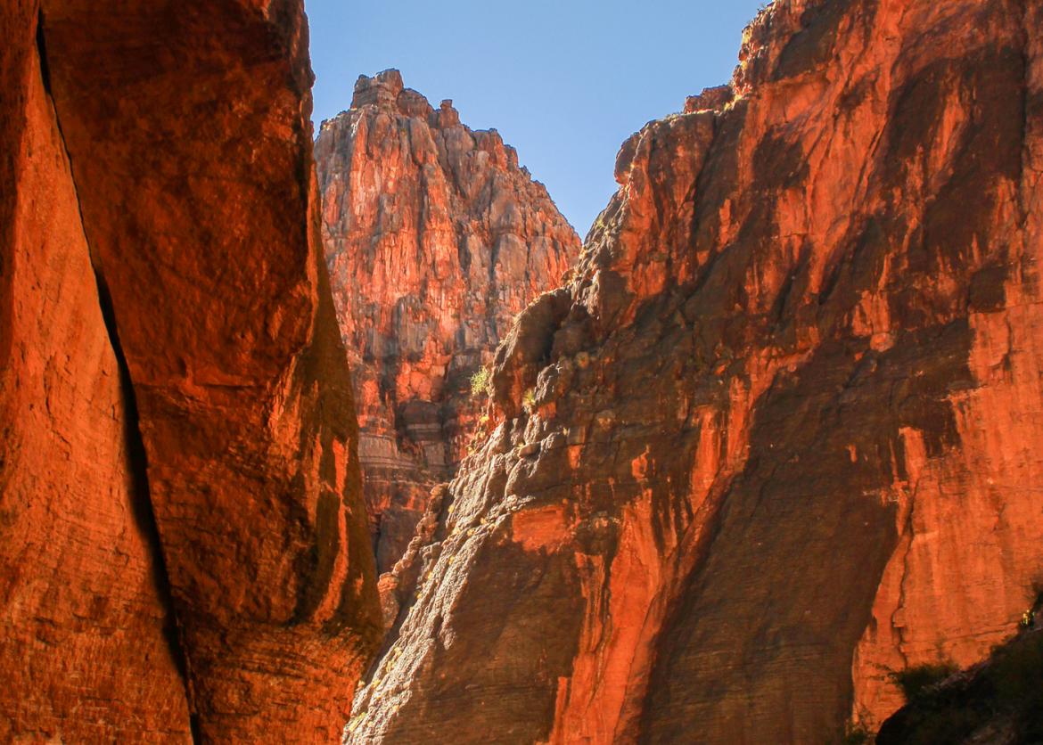
Kanab Canyon is a Grand Canyon treasure. Our journey will take us through some of the most spectacular country in the world. Remote and infrequently traveled, our route will take us to Scotty's Hollow, Showerbath Springs, and Whispering Falls, which are secret oases in this rugged country. Our route to Kanab will be along a broad red Esplanade shelf to Sowat’s Canyon and Mountain Sheep Spring
In an effort to get more young folks into the wilderness, we're offering adults 18-35 years old a full $300 off this trip. Visit our scholarships page for details on how to apply.
The Trip
Note: Applications for backcountry permits in the Grand Canyon will not be confirmed until the middle of May. As a result, the itinerary and dates for this trip could change.
Kanab Canyon is a Grand Canyon treasure. Our journey will take us through some of the most spectacular country in the world. Remote and infrequently traveled, our route will take us to Scotty's Hollow, Showerbath Springs, and Whispering Falls, which are secret oases in this rugged country. Our route to Kanab will be along a broad red Esplanade shelf to Sowat’s Canyon and Mountain Sheep Spring. If we are lucky we might spot one of the endangered condors or a desert bighorn along the way. Kanab is relatively narrow with walls more than 1,000 feet high. As a result, we will enjoy considerable shade as we journey down this hauntingly beautiful gorge. As we retrace part of our route, we will explore Indian Hollow and Ojojojo Canyon, eventually returning to the Esplanade. On a dayhike, we will stroll along the Esplanade and reach the top of Racetrack Knoll, where we take in stunning 360-degree views of this isolated corner of the Grand Canyon.
Some of our days will be challenging and long, but we will take time to enjoy this vast and magnificent wilderness. The weather is usually dry this time of year so rain should not be a problem. Usually warm during the day (about 85 degrees) and cooler at night (about 65 degrees), the weather can be ideal. On the Esplanade at more than 5,000 feet, the weather will be a little cooler but not cold. Because of the warmth, we can keep our clothing to a minimum and have relatively light packs, although Canyon weather can vary significantly and be windier, hotter, colder, or wetter than expected.
About 13,000 years ago, humans made their first impressions in the Grand Canyon area. John Wesley Powell's exploration of the Colorado River in 1869 led prospectors, railroad men, and promoters to dream of ways to turn the wonders of the Grand Canyon into personal fortunes. Yet not until after World War II did tourists and hikers begin to seek out the area's beauty and solitude. Harvey Butchart and his family came to Flagstaff during the postwar period to teach mathematics at Northern Arizona University. He discovered the joys and challenges of the Grand Canyon and for the next 40 years spent much of his free time exploring the backcountry of this fabulous place. His routes, maps, and notes opened the Canyon to a myriad of backpackers, like us.
The North Rim is a vast area that relatively few people visit. About five million people visit the South Rim each year and only 60,000 of them make it into the 1.2-million acres of backcountry. Far fewer people visit the North Rim or venture into its backcountry. Thus, the North Rim, which is about 1,000 feet higher than the South Rim, offers greater opportunities for our group to enjoy the solitude and special quiet of the Canyon.
Itinerary
Day 1: We will meet early in front of a hotel in Kanab, Utah to caravan two hours to the trailhead near Sowats Point at about 6,200 feet. After a brief trailhead talk we will hike on a fairly good trail down to the Esplanade at 5,400 feet and then cross the broad expanse of the Esplanade, until we get to Sowat’s Canyon. We’ll pause at this point and take a dayhike up this beautiful canyon before returning to our packs for an easy off-trail hike of less than a mile down Sowat’s to Mountain Sheep Spring (3,700 feet) where we will spend the night
Day 1: We will meet early in front of a hotel in Kanab, Utah to caravan two hours to the trailhead near Sowats Point at about 6,200 feet. After a brief trailhead talk we will hike on a fairly good trail down to the Esplanade at 5,400 feet and then cross the broad expanse of the Esplanade, until we get to Sowat’s Canyon. We’ll pause at this point and take a dayhike up this beautiful canyon before returning to our packs for an easy off-trail hike of less than a mile down Sowat’s to Mountain Sheep Spring (3,700 feet) where we will spend the night. Today’s hike is about five miles on mostly good trails with a descent of 2,500 feet (add another two to three miles for the dayhike).
Day 2: From this point on we will be hiking off-trail until we leave the Esplanade on our last day. Today we hike less than a mile to Jumpup Canyon (a beautiful narrow slot canyon in its lower reaches), which we follow four miles to the junction with Kanab Canyon. We will continue to make our way down-canyon from the Kanab-Jumpup junction for four more miles, running into permanent flowing water along the way. We will camp on a sandy bench just before Showerbath Spring and a great swimming hole. Today we hike eight to nine miles and lose about 800 feet of elevation.
Day 3: Getting an early start, we hike about one mile to Scotty’s Hollow where we will drop our packs. Taking our time, we will explore Scotty’s Hollow where there will be some refreshing pools to cross. We will hike about a mile up Scotty’s Hollow. After lunch we will return to our packs and continue our journey down Kanab to a comfortable campsite closer to Whispering Falls about 400 feet lower than where we started. Today we will hike about eight miles without packs, and then maybe another two or three miles with packs, with 1,000 feet of elevation gain or loss.
Day 4: Our journey continues for three to four miles down Kanab this morning (without packs) to Whispering Falls. At Whispering Falls we can take a cool swim and then return to our camp. Depending on our energy we might attempt to hike down to the Colorado River and then hike back up Kanab toward Showerbath Springs to camp for the night or simply stay at the same camp as the night before. Today we will hike about seven to eight miles without packs, and then maybe another two or three mile with packs, with only a few hundred feet of elevation gain and loss.
Day 5: Retracing our steps up Kanab we can enjoy this marvelous canyon from another perspective. We’ll take a look at lower Indian Hollow, which is blocked upstream by a large chockstone called Hotel Chockstone. Hiking to Kwagunt we will then use a route on top of the Redwall to get into Indian Hollow above Hotel Chockstone. We’ll camp either at the Kwagunt junction with Jumpup or in Indian Hollow if we make it that far. Our hike is about eight to nine miles with an ascent of 800-900 feet.
Day 6: Today we will hike up to the Esplanade without packs. The hiking is relatively easy with sweeping vistas. Our goal is the top of Racetrack Knoll, which rises about 500 feet above the surrounding Esplanade. We will enjoy stunning views from this unique landmark. We will then return to our packs and camp on a lovely slickrock bench in Indian Hollow. Today our hike is about eight miles with an elevation gain and loss of about 700 feet.
Day 7: Ascending to the Esplanade from Indian Hollow we will enjoy a breathtaking camp on the Esplanade for our last night. We might take a dayhike to Indian Hollow spring (not in Indian Hollow) depending on available time and energy. With packs we will only hike about two to four miles, but we may add several more miles on a dayhike. Our elevations change will be about 400 feet in elevation gain.
Day 8: Our last day will be mostly easy scenic hiking along the Esplanade, reconnecting with the trail that we came down on our first day. We will ascend on this trail for about two miles back to the trailhead and our vehicles. Today we hike six miles with an elevation gain of 2,000 feet. We'll caravan back to Kanab, where we can enjoy a well-deserved lunch together.
Note: The exact itinerary for the trip may vary from what is described above depending on the weather, water availability, and the strength and preferences of the group. The trip officially begins and ends at the trailhead near Sowats Point.
Logistics
Getting There
Plan to arrive at Kanab at 4 p.m. on the evening before the trip begins. We will meet for a trip briefing and to distribute equipment at that time. Do not plan on leaving Kanab until about 3 p.m. on our last day. From Las Vegas, it is about 200 miles (3 hours' driving time) and from Salt Lake City it is 312 miles (5 hours' driving time). It will take us about two hours to caravan the 60 miles together to the trailhead near Sowat’s Point, where we will leave our vehicles for the week and begin our journey. The mostly dirt road is in generally good condition, but a high-clearance vehicle is needed. Please do not make non-refundable travel arrangements until notified to do so by the trip leader
Getting There
Plan to arrive at Kanab at 4 p.m. on the evening before the trip begins. We will meet for a trip briefing and to distribute equipment at that time. Do not plan on leaving Kanab until about 3 p.m. on our last day. From Las Vegas, it is about 200 miles (3 hours' driving time) and from Salt Lake City it is 312 miles (5 hours' driving time). It will take us about two hours to caravan the 60 miles together to the trailhead near Sowat’s Point, where we will leave our vehicles for the week and begin our journey. The mostly dirt road is in generally good condition, but a high-clearance vehicle is needed. Please do not make non-refundable travel arrangements until notified to do so by the trip leader.
Accommodations and Food
Our first trip meal will be lunch on our first day and the last meal will be breakfast on our final day in the Canyon. Trip meals will include some meat, but vegetarians can be accommodated. Trip participants share in meal preparation and clean up. We try to bring enough food so everyone is satisfied, but we also want to keep our packs as light as possible. We try to make the food appetizing but fairly simple to make. From our past feedback everyone will likely be more than satisfied.
Trip Difficulty
We cover approximately 40 miles with our packs on this trip. And all of the optional exploring without packs will add another 20 miles. Also we have several thousand feet of elevation change during the course of the week. Our average daily distance with packs is about six miles, but most of the hiking is off trail, and if you add in all of the day hiking the average distance is closer to 8 miles. The hiking is surprisingly varied with stretches of easy flat hiking on the Esplanade alternating with stretches of continuous boulder hopping in the stream in Kanab Canyon. All backpack trips are physically challenging, and Grand Canyon backpack trips can be especially demanding with dramatic elevation changes, unstable footing, exposure to the sun, and potentially hot temperatures.
This trip is rated moderate to strenuous (Level 4). There may be sections that feel more like a strenuous outing (Level 5), such as descending into and ascending out of the Canyon and scrambling up side canyons. Short stretches along the canyon floors or hiking on the Espanade trails feel like a moderate hike (Level 3). Because of the rating, participants must be committed to seriously training for this outing for three months or more months prior to the start of the trip, depending on one's physical condition. The leaders will gladly share a training routine that has been successful for others on Grand Canyon trips. Overall, this trip on average is in the middle of the 4 rating compared to the Sierra Club’s other Grand Canyon backpack trips due to all the off-trail hiking. Some backpacking experience is needed.
Equipment and Clothing
A specific equipment list will be sent later after you have signed up for the trip.
References
- The following USGS 7.5 minute series maps will cover our route: Jumpup Point, Kanab Point, Fishtail Mesa.
- Ranney, Wayne, Carving Grand Canyon (2nd ed). Grand Canyon Association, 2012. Read about how the Grand Canyon may have come into existence.
- Davis, Wade, River Notes: A Natural & Human History of the Colorado. Island Press, 2012. This is an excellent summary of how the once mighty and majestic Colorado has become the dammed and highly regulated river that it is today.
- Fedarko, Kevin, The Emerald Mile. Scribner, 2014. Fedarko weaves canyon lore and history into this gripping account of the fastest rafting trip in the Canyon.
- Osborne, Sophie A. H., Condors in Canyon Country: The Return of the California Condor to the Grand Canyon Region. Grand Canyon Association, 2008. An epic attempt to save a great bird.
- Childs, Craig, House of Rain: Tracking a Vanished Civilization Across the American Southwest. Back Bay Books, 2008. A non-fiction cultural adventure about the Anasazi or Ancestral Puebloan.
- Price, L. Greer, An Introduction to Grand Canyon Geology. Grand Canyon Association, 1999. An accessible book with plenty of illustrations and photos about Grand Canyon geology.
- Anderson, Michael F., Living at the Edge. Grand Canyon Association, 1998. About the colorful pioneering people of European descent who first explored and settled in the Grand Canyon.
- Houk, Rose, An Introduction to Grand Canyon Ecology. Grand Canyon Association, 1996. A brief primer on the complex web of life in the Canyon.
- Coder, Christopher M., An Introduction to Grand Canyon Prehistory. Grand Canyon Association, 2006. A short overview of the early people of the Grand Canyon area.
- Huisinga, Ann, Lori Makarick, and Kate Watters, River and Desert Plants of the Grand Canyon. Mountain Press Publishing, 2006. A great reference for the common shrubs, trees, and flowers of the Inner Canyon.
- The Grand Canyon Association is a great resource with many books of interest: http://www.grandcanyon.org
Conservation
There are numerous conservation issues regarding the Grand Canyon: the Escalade proposal, Tusayan expansion plans, the introduction of condors, noise from sightseeing aircraft, air quality over the park, uranium mining threats, control of the Colorado River by the Glen Canyon Dam, and visitor management, including backcountry use. The biggest issue though is water use in the West by burgeoning cities such as Las Vegas, Phoenix and Tucson. These cities largely depend on the Colorado River for their water and are running it dry. The Southwest is in the grips of a 15-year drought; water levels in Lake Mead and Lake Powell are roughly 50% of capacity and are at historic lows since they filled decades ago.
Sierra Club National Outings is an equal-opportunity provider and will operate under permits from Kaibab National Forest and Grand Canyon National Park.
Staff


Important Notes
- Carbon Offsets
- Carpooling
- Electronic Billing and Forms
- Electronic Devices
- Equipment
- Essential Eligibility Criteria
- How to Apply for a Trip
- Leader Gratuities
- Medical Issues
- Non-discrimination Statement
- Participant Agreement
- Seller of Travel Disclosure
- Single Supplements
- Terms and Conditions
- Travel Insurance
- Trip Feedback
- Trip Price
- Wilderness Manners