Treasures of Blackcap Basin and the White Divide, Kings Canyon National Park, California
Sierra Club Outings Trip | Backpack
Highlights
- Visit remote Blue Canyon and Goddard Creek
- Hike challenging off-trail routes over the White Divide
- Explore or relax on two planned layover days
Includes
- Great meals for vegetarians and non-vegetarians alike -icon-: Meals
- Group cooking gear including bear canisters -icon-: Gear/equipment (kayak, tent, safety)
- All pre-trip planning and permits -icon-: Permits/visas
Overview
The Trip
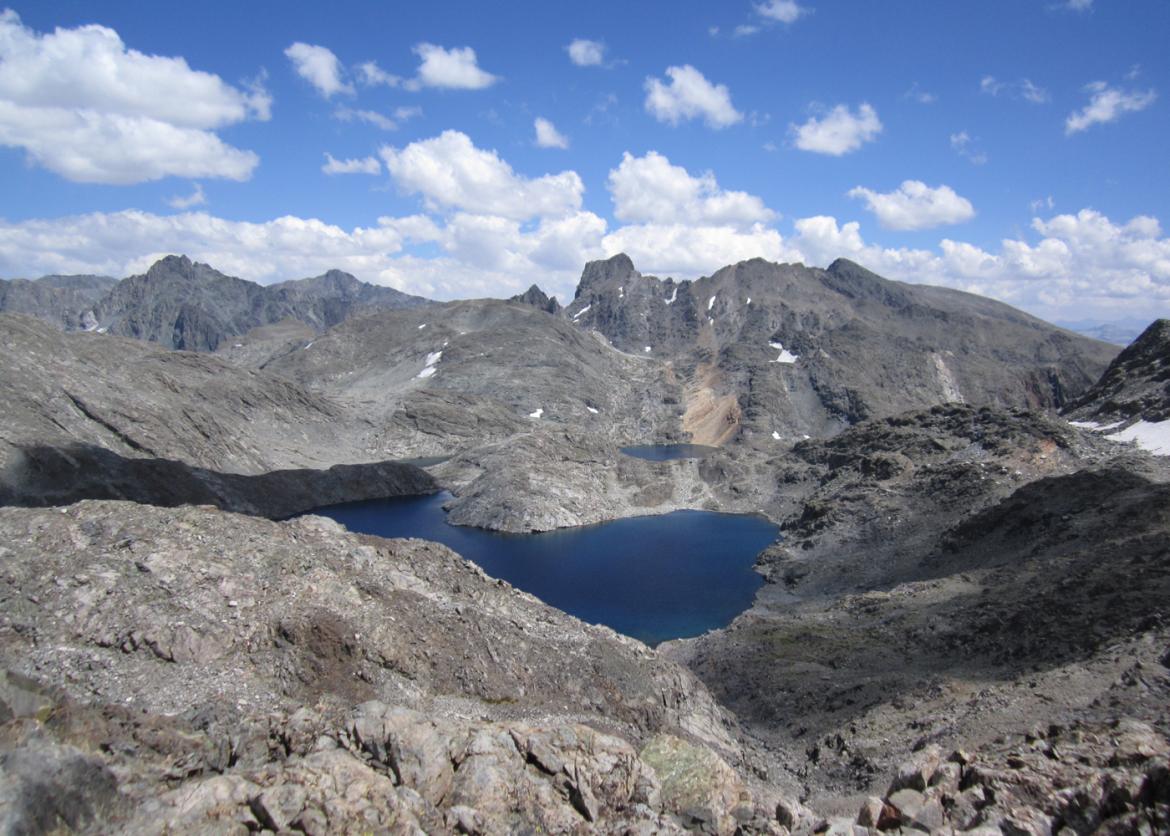
This trip for experienced backpackers will venture off-trail deep into remote lake basins of Kings Canyon National Park. Our goal is to explore beautiful Blue Canyon, the headwaters of Goddard Creek that lie in the shadow of Mt. Reinstein, and the numerous lakes dotting picturesque Blackcap Basin. Once we reach Kettle Ridge, we will depart from established trails to find our way across the ridge into seemingly inaccessible lake basins that are nestled along the White Divide. It is likely that we will encounter few, if any, other visitors in this wild, rugged region of the Sierra Nevada
The Trip
This trip for experienced backpackers will venture off-trail deep into remote lake basins of Kings Canyon National Park. Our goal is to explore beautiful Blue Canyon, the headwaters of Goddard Creek that lie in the shadow of Mt. Reinstein, and the numerous lakes dotting picturesque Blackcap Basin. Once we reach Kettle Ridge, we will depart from established trails to find our way across the ridge into seemingly inaccessible lake basins that are nestled along the White Divide. It is likely that we will encounter few, if any, other visitors in this wild, rugged region of the Sierra Nevada.
We begin our adventure at Wishon Reservoir on the western slope of the High Sierra. Our scenic route embarks on trail as we hike eastward toward the White Divide. After passing through Crown Valley, we will follow an old unmaintained trail across Kettle Ridge into Blue Canyon to make camp in its idyllic upper basin. A planned layover day will give us the opportunity to explore the lake-filled canyon, or perhaps hike up to Tunemah Lake.
Working our way north from Blue Canyon, we pass Finger Peak as we cross the White Divide and enter the upper reaches of Goddard Creek. There we’ll camp at one of the many lakes in the high alpine basin. Depending on our progress, we may have time for another layover day, during which we might choose to take a peek into nearby Ionian Basin. Scylla and The Three Sirens, guardians of the Enchanted Gorge, tempt us.
Traversing two cross-country passes, we will cross the Le Conte Divide near Mt. Reinstein and enter Blackcap Basin. We will spend two days and nights in this scenic basin as we find our way back to the vehicles we left parked at the trailhead.
Itinerary
Our hiking schedule is not rigid. How far we get each day and where we camp depends on how we feel, the weather, and other factors outside of our control. There may be portions of the route that were not scouted by the leaders before the trip -- some additional scouting may be required during the trip. Flexibility is important. The itinerary described here should be taken as a general plan, and the actual route and schedule may vary depending on the conditions we encounter
Our hiking schedule is not rigid. How far we get each day and where we camp depends on how we feel, the weather, and other factors outside of our control. There may be portions of the route that were not scouted by the leaders before the trip -- some additional scouting may be required during the trip. Flexibility is important. The itinerary described here should be taken as a general plan, and the actual route and schedule may vary depending on the conditions we encounter.
Day 1: The trip will begin with a potluck dinner on Thursday, August 11 at a campground near Wishon Reservoir (6,600 feet elevation) in Sierra National Forest, approximately 75 miles east of Fresno. The evening will be a great time for us to meet our backpacking companions and relax over a meal together before beginning our adventure. We will also go over trip procedures, give ourselves one more night to acclimate to the high elevation, and finish preparations for our journey.
Although the trip begins on Thursday evening, we encourage participants to arrive a day or two early to start acclimatizing to the high elevations we will encounter during the trip. Giving your body an extra couple of days to adjust to the high elevation can often make a big difference between enjoying the trip or merely just enduring it.
Day 2: After an early morning breakfast at the campground, we will drive several miles to our trailhead, stopping along the way to leave some of our vehicles parked at our exit trailhead. We will begin hiking eastward toward Crown Valley, where we plan to camp for the night. (9.6 miles, 2,200 feet of elevation gain)
Days 3-4: We will cross Kettle Ridge on an unmaintained trail and hike northward, following Blue Canyon Creek. After camping along the creek, we will head off-trail to a lake in the upper basin beneath the White Divide and spend two nights there above 10,000 feet. Over two days, we will hike nearly 13 miles with 5,700 feet of elevation gain.
Day 5: Today is a layover day at our camp high above Blue Canyon. We may choose to relax, explore the lake basin, or hike an ambitious route over to Tunemah Lake.
Days 6-8: Rising early, we will hike a challenging cross-country route over Blue Canyon Pass toward upper Goddard Creek to the beautiful lake basin just east of Mt. Reinstein. From there we traverse two cross-country passes, skirting around Mt. Reinstein to leave the most rugged terrain of our adventure behind us. Crossing over the Le Conte Divide, we enter Blackcap Basin to camp beside one of its many lakes near the White Divide. Our plan is flexible. We may find time for another layover day, during which some may choose to venture into talus-filled Ionian Basin to explore its desolate lakes or features named from Greek mythology: Scylla, The Three Sirens, and Charybdis. (13 miles with 2,600 feet elevation of gain over 2-3 days)
Days 9-10: We will spend the final two days of our adventure enjoying our 20-mile trek on-trail through Blackcap Basin and Woodchuck Country back to our cars parked near Wishon Reservoir. We plan to make camp at a lake along our route.
Logistics
Getting There
Our trip starts on Thursday, August 11 at a campground near Wishon Reservoir in the Sierra National Forest, approximately 75 miles east of Fresno, 250 miles east of San Francisco, and 300 miles north of Los Angeles. If you’re traveling from out of state, the closest airport is the Fresno International Airport. There is no public transportation to the area, but a roster of the participants and their contact information will be provided well ahead of the trip to assist those who would like to arrange carpools. Detailed driving directions will also be provided
Getting There
Our trip starts on Thursday, August 11 at a campground near Wishon Reservoir in the Sierra National Forest, approximately 75 miles east of Fresno, 250 miles east of San Francisco, and 300 miles north of Los Angeles. If you’re traveling from out of state, the closest airport is the Fresno International Airport. There is no public transportation to the area, but a roster of the participants and their contact information will be provided well ahead of the trip to assist those who would like to arrange carpools. Detailed driving directions will also be provided.
Please do not make non-refundable travel arrangements until notified to do so by the trip leader.
Accommodations and Food
All on-trip meals, beginning with breakfast on our first hiking day (Friday, August 12) and including lunch on our last day (Saturday, August 20), are included in the trip fee. The leader enjoys planning meals that are flavorful, diverse and, at times, atypical of usual backpacking fare. We will provide a menu that appeals to vegetarians and non-vegetarians alike. It is our goal to feed you well so that you are well fueled for our days of hiking. All cooking gear and stoves are provided. Trip members will be divided into cook crews to help prepare our meals and wash the pots and pans afterward.
Trip Difficulty
The trip is rated 5 (on a scale of 1 for our least difficult trips to 5 for our most difficult trips) and is well suited for experienced backpackers with recent backpacking experience. Several days during the trip will involve long distances with large elevation gains and cross-country travel. Elevations on this trip will range from 6,600 to 12,000 feet, and our campsite elevations will range from 7,200 to over 11,000 feet. Total mileage for the trip on seven moving days will be nearly 60 miles.
Participants are highly encouraged to arrive a day or two prior to the trip start date to spend some time at altitude (above 6,000 feet) to help with acclimatization. Participation in this outing requires that you have recent backpacking experience, are in excellent physical condition, and have reasonable expectations for the trip. Very good aerobic conditioning and lots of pre-trip training that includes steep hill climbs are essential. Experience in cross-country backpacking is helpful as hiking on rough, rocky terrain does require good balance and a patient, tolerant attitude, both of which are requirements for the trip.
Group wilderness trekking requires a collaborative team-first approach. We look out for each other and sometimes have to compromise our individual goals for the overall experience of the group. The conditions we encounter may require a change in route or itinerary, and the positive attitude of our trip participants will greatly affect the quality of experience for the entire group. Our objectives are to enjoy some spectacular country and to complete the trip safely as a group.
August in the High Sierra typically brings beautiful weather conditions. However, backpacking in remote wilderness areas requires that we be prepared for extreme conditions that can occur at any time. At lower elevations temperatures can reach 80 degrees, while nights at high elevations can dip into the 20s. Thunderstorms or snowstorms can occur at any time of the year, with sudden bursts of wind, rain, lightning, and hail.
Participants are expected to assist with cooking, food storage, cleaning, camp set-up and camp breakdown. We will follow Leave No Trace guidelines throughout the trip.
Equipment and Clothing
A list of suggested personal equipment will be sent to all participants when they sign up for the trip. If you would like to see the list before signing up, let the leader know and she will send you a copy. Participants should keep the weight of their personal gear well below 25 pounds; preferably under 20 pounds, including their backpack. We will give you approximately 16 to 18 pounds of commissary equipment and food at the beginning of the trip. With that, plus 2.5 pounds for 2 liters of water, your total pack weight should weigh less than 45 pounds at the beginning of the trip.
We will provide all food and cooking equipment, though you must bring your own eating utensils. Some of the group equipment is relatively bulky, particularly cooking pots and bear canisters. Your pack should be sufficiently large to carry an item about the size of a full paper grocery bag in addition to your personal gear. We recommend that your pack have 4,000 cubic inches, or 65 liters of carrying capacity. The leader will send detailed equipment recommendations to participants well in advance of the trip. More information regarding personal gear may be found at the following link:
http://www.knapsack.org/basic_equipment.html
Although Sierra summers are relatively dry, we could have rain at any time. For shelter, tents are strongly encouraged and lightweight waterproof tarps are the required minimum. Where possible, we will help participants contact other trip members who want to share shelters. For rain gear, you should bring a waterproof jacket and rain pants rather than a poncho.
References
Please bring your own map and compass -- not only is this a matter of safety, but you will have a better appreciation of where we are going and where we have been.
Maps:
- The USGS 7.5-minute “Blackcap Mountain,” "Courtright Reservoir," "Mt. Goddard," “Rough Spur,” and “Sllde Bluffs” quadrangles together cover our planned route.
- The Kings Canyon High Country map published by Tom Harrison Maps (www.tomharrisonmaps.com) covers most of the trip and, although it doesn't provide as much detail as the 7.5 minute maps, is a good general map of the area.
- National Geographic’s Trails Illustrated “Sequoia Kings Canyon National Parks” map is also a good general reference.
Maps may be purchased online:
Books:
- Secor, R.J., The High Sierra: Peaks, Passes, and Trails. The Mountaineers. An excellent general reference to climbing routes, cross-country routes, and trails in the Sierra Nevada.
- Laws, John Muir, The Laws Field Guide to the Sierra Nevada. California Academy of Sciences. A general reference to Sierra life. It covers trees, wildflowers, fish, reptiles, amphibians, birds, mammals, and other life in the mountains.
Conservation
The Sierra Club is an environmentally focused entity. We are concerned about conservation and the sustainability of resources, both locally and globally. Our work is accomplished by volunteers and aided by a salaried staff, encouraging grassroots involvement. Our outings seek to empower participants toward greater understanding, advocacy, and participation in the goals of the Club.
We will venture off-trail into pristine alpine lake basins, which appear today much as they must have to the early mountaineers of the 19th century. We will share the mountaineers' stories and their visions for ensuring the preservation of this treasured wilderness for many generations to come. As a group we will diligently observe Leave No Trace principles, and invite discussion of current efforts to protect our wilderness lands.
While the area we're visiting has been protected, it continues to be threatened by outside forces such as climate change and pollution. Many of the surrounding areas are unprotected and face additional threats such as logging and poorly planned development. We'll have an opportunity on our outing to discuss such threats, the importance of large protected areas for habitat resilience, and what we can do to support work on these issues. Participants are also encouraged to share information about other environmental issues, such as those in their local communities.
Visitors like us have an effect on the wilderness. Our trip will provide a good opportunity to observe why it is important to minimize our impact and consider ways in which we can leave no trace. We may also discuss how wilderness practices have changed over the years and how they can be further improved, while at the same time allowing for a special experience in the wilderness.
Sierra Club National Outings is an equal-opportunity provider and will operate under permits from Sequoia & Kings Canyon National Park and Sierra National Forest.
Staff
Photos


Important Notes
- Carbon Offsets
- Carpooling
- Electronic Billing and Forms
- Electronic Devices
- Equipment
- Essential Eligibility Criteria
- How to Apply for a Trip
- Leader Gratuities
- Medical Issues
- Non-discrimination Statement
- Participant Agreement
- Seller of Travel Disclosure
- Single Supplements
- Terms and Conditions
- Travel Insurance
- Trip Feedback
- Trip Price
- Wilderness Manners