Kayaking Coastal Virginia: Blackwater and Beach
Sierra Club Outings Trip | Kayak
Highlights
Includes
Overview
The Trip
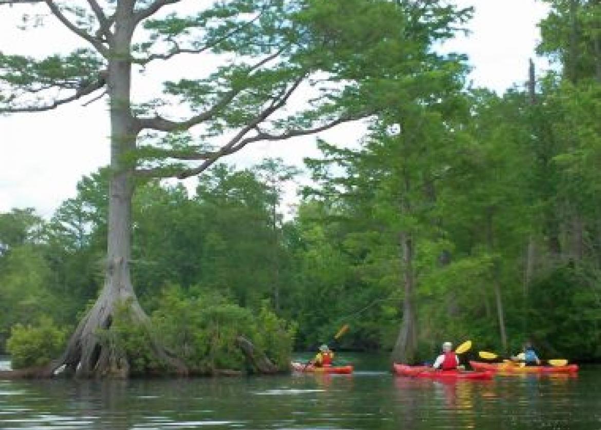
Coastal Virginia is a landscape of intimate natural diversity.
The coastal plain flows east from the fall line, and forms a maze of hundreds of rivers, creeks, freshwater and saltwater marshes, cypress swamps, salty bays, and barrier islands.
Names like Blackwater River, West Neck Creek, or Great Dismal Swamp will not ring a bell for most people. However, after kayaking these and other diverse waterways, you will leave each with reluctance, not knowing if you will find another one quite as beautiful. The beauty of these waterways manifests itself in numerous ways: searching for ospreys and other wildlife while paddling a clear blue bay; spotting a dolphin surface nearby as you gently dip your paddle in and out of the water; being stunned by the primitive nature and quiet of an ancient cypress swamp; paddling though the delicate beauty of a winding water
The Trip
Coastal Virginia is a landscape of intimate natural diversity.
The coastal plain flows east from the fall line, and forms a maze of hundreds of rivers, creeks, freshwater and saltwater marshes, cypress swamps, salty bays, and barrier islands.
Names like Blackwater River, West Neck Creek, or Great Dismal Swamp will not ring a bell for most people. However, after kayaking these and other diverse waterways, you will leave each with reluctance, not knowing if you will find another one quite as beautiful. The beauty of these waterways manifests itself in numerous ways: searching for ospreys and other wildlife while paddling a clear blue bay; spotting a dolphin surface nearby as you gently dip your paddle in and out of the water; being stunned by the primitive nature and quiet of an ancient cypress swamp; paddling though the delicate beauty of a winding waterway engulfed in marsh; paddling past century-old trees that line the shoreline, wishing that they could speak to you and tell you countless stories of times past. Coastal Virginia contains a blend of waterways, trails, beach, and history that offer a real opportunity for modern-day exploration.
Itinerary
Day 1: The outing will officially start at First Landing State Park at 4 p.m. We'll assign cabins, go over the itinerary, and have a delicious welcome dinner. After dinner, we'll have the option of walking on the beach.
Day 2: After a tasty breakfast, we'll get everyone geared up for an exciting week of kayaking and exploring! We'll give paddling and safety instruction and then embark on our first adventure, first kayaking Broad Bay, within First Landing State Park. Lunch will be on a remote, preserved stretch of beach. Next, we'll stop to explore Cape Henry Lighthouse, the oldest lighthouse in the entire U.S. After dinner, we'll enjoy an exciting presentation on Chesapeake Bay by a local expert. This will be an exciting and action-packed first day!
Day 3: Nestled between Back Bay and the Atlantic Ocean, False Cape State Park is one of the last remaining undeveloped areas along the Atlantic coast. We'll start the day by kayaking the beautiful waterways of Back Bay National Wildlife Refuge. This will be a good day for birding. After lunch, we'll go on a guided tram tour of False Cape State Park, exploring some of the miles of preserved beach and trails.
Day 4: Our next kayak adventure will be in The Great Dismal Swamp. After a roughly one-hour drive, we'll cross the border into North Carolina and stop at the visitor center. Next, we’ll kayak out to Lake Drummond, where the surreal landscape and primitiveness will amaze you. This area is a cornucopia of varied tree species, birds, and mammals. It's a bit of a drive and a long day, but worth every minute!
Day 5: Launching from the West Neck marina, we will explore what is widely considered to be the most beautiful cypress creek waterway in the Virginia Beach area. We hope to get up close to view established osprey nests in the area. There is also the possibility of seeing great blue heron, green heron, bald eagle, deer, and river otter. Time permitting, we’ll stop off to visit the Old Coast Guard Station on the way back, where maritime history comes to life.
Day 6: A trip to the Virginia Eastern Shore via the Chesapeake Bay Bridge-Tunnel. Crossing the bridge-tunnel is a thrill in itself, and we'll stop off and take in the view at one of the several viewing areas. The Eastern Shore NWR is one of the most important avian migration funnels in North America with a unique and interesting visitor center.
Each fall, the refuge is the scene of a colorful drama as millions of songbirds and monarch butterflies and thousands of raptors converge at the peninsula’s tip. We will visit the Eastern Shore Visitor Center first to get an overall picture of the Refuge. Next, we’ll take you to one of our secret kayak spots and enjoy our last paddle of the outing. Today will be a good day to search for songbirds, ospreys, swans, chickadees, and brown pelicans -- and we may even catch a glimpse of river otters. We'll cap off the day with a farewell dinner at one of the unique local Eastern Shore seafood restaurants, and hopefully catch the sunset while driving the bridge-tunnel back.
Day 7: We will eat a farewell breakfast, then pack up and say goodbye to new friends after an amazing week of kayaking and exploring Coastal Virginia.
Logistics
Getting There
Norfolk, Virginia has the closest airport to our lodging at First Landing State Park. Washington, DC or Baltimore, MD have larger airports and also may offer you better airfares, but they are a three-hour drive to our lodging. Directions will be provided and a group roster will be sent to all participants several months in advance of the outing. We encourage carpooling to and from the outings, and we will carpool and caravan to our various destinations throughout the week. We will need volunteer drivers and you will be asked to give or get a ride throughout the week. Please do not make non-refundable travel arrangements until notified to do so by the trip leader
Getting There
Norfolk, Virginia has the closest airport to our lodging at First Landing State Park. Washington, DC or Baltimore, MD have larger airports and also may offer you better airfares, but they are a three-hour drive to our lodging. Directions will be provided and a group roster will be sent to all participants several months in advance of the outing. We encourage carpooling to and from the outings, and we will carpool and caravan to our various destinations throughout the week. We will need volunteer drivers and you will be asked to give or get a ride throughout the week. Please do not make non-refundable travel arrangements until notified to do so by the trip leader.
Accommodations and Food
We will spend six nights in cozy state park cabins at First Landing State Park in Virginia Beach, Virginia. Miles of hiking trails and Chesapeake Bay beach are nearby within the park. The cottages have an equipped kitchen, bathroom, shower, and patio.
Participants will take turns helping the leaders prepare meals and clean up.
The first meal will be dinner on day one of the outing, and the last meal will be breakfast on day seven. We will go out to dinner once during the week and this dinner is not included in the trip price. Vegetarians can be accommodated.
Trip Difficulty
We will paddle intermediate routes, averaging 6-10 miles and 3-5 hours on the water each day. You need not be an expert paddler, but you should have previous kayaking experience. Basic paddling and safety instructions will be given on the first day of the outing. Hikes will be 1-5 miles in distance on level terrain or sandy beaches. Each participant should understand that this is a group outing and he/she will be required to stay with the group while we are on the water or trail.
We encourage carpooling to and from the outing and we will carpool and caravan to our various destinations throughout the week. We will need volunteer drivers to make this happen. Drive times will vary from 30-60 minutes each way. You should be flexible as plans and itineraries often change due to tides, weather, water levels, group ability, or other unforeseen reasons.
Note: Please be aware that ticks, poison ivy, and the occasional snake are all possibilities in this area.
Equipment and Clothing
We will provide a rental kayak, PFD/life jacket, and paddle to each participant. We will provide all group cooking gear. You will need to bring a reusable lunch container, water bottles(s), and a dry bag(s) to use throughout the week.
A daypack will also be useful and you will need to have a personal first-aid kit. We will need volunteer drivers with vehicles as we will carpool throughout the week. A full gear list will be sent to all participants prior to the outing.
References
- Winegar, Deane, Longstreet Highroad Guide to the Chesapeake Bay. RR Donnelley and Sons, 2000.
- Gilbert, Lillie and Vickie Schufer, Wild River Guide to Great Dismal Swamp Water Trails. ECO Images, 2004.
- Gilbert, Lillie and Vickie Schufer, Wild River Guide to the North Landing River and its Tributaries. ECO Images, 2001.
- Badger, Curtis, A Naturalist's Guide to the Virginia Coast. University of Virginia Press, 2004.
Conservation
The Chesapeake Bay covers 2,500 square miles and is North America’s largest estuary. An estuary is a partially enclosed area where a river's fresh water mixes with tidal saltwater. If you decided to explore every cove and inlet of Chesapeake Bay, tracing the shoreline around the bay, you would end up traveling roughly 4,000 miles!
Rain falls over a roughly 64,000-square-mile area known as the Chesapeake Bay Watershed. About 15 million people and 6 states are included in this watershed. The Chesapeake Bay Foundation releases an annual report that describes the state of the bay each year.
The state of the bay is rated on a scale of 1-100. An all-time low of 23 was recorded in 1983, and the number improved to 28 in 2000 and 32 in 2012. Although this trend shows improvement, the bay’s health is still rated as poor. Monitoring and continuous effort must be made in order for the bay to have a chance to continue to recover. We will experience the beauty of the Chesapeake Bay up close and discuss the mounting pressures on the health of the bay. These pressures include: urban sprawl and growth in the watershed, increasing human population around the bay, and the continued loss of wetlands, forests, and open space that buffer the bay’s waters. If we fail to change the way that we currently do things, losing the Chesapeake Bay is a real possibility.
Sierra Club National Outings is an equal-opportunity provider and will operate under permits from Great Dismal Swamp and Eastern Shore National Wildlife Refuges.
Staff
Photos
Important Notes
- Carbon Offsets
- Carpooling
- Electronic Billing and Forms
- Electronic Devices
- Equipment
- Essential Eligibility Criteria
- How to Apply for a Trip
- Leader Gratuities
- Medical Issues
- Non-discrimination Statement
- Participant Agreement
- Seller of Travel Disclosure
- Single Supplements
- Terms and Conditions
- Travel Insurance
- Trip Feedback
- Trip Price
- Wilderness Manners