
Highlights
- Run exciting rapids in rafts and inflatable kayaks
- Hike in scenic red rock canyons
- Explore Native American ruins and rock art
Includes
-
All rafts, kayaks, paddleboards, and equipment
-
All meals and snacks from day 2 lunch to day 6 lunch
-
Van transportation from hotel to put-in and take-out
Overview
Born in the snows of the Continental Divide in Colorado, the San Juan River traverses the northwest corner of New Mexico before cutting its canyons into Utah near the Four Corners Monument. It then meanders through deep, painted canyons in southeast Utah where our trip takes place, and eventually joins the Colorado River in what is now Lake Powell. The section of river that we raft is known for its spectacular natural beauty and fascinating human history.
Our trip offers a leisurely 83-mile journey through a place unlike any other. We'll drift past contoured slickrock, visit some of Utah’s most spectacular petroglyph panels, see an Ancestral Puebloan ruins site, and run warm-water rapids
Born in the snows of the Continental Divide in Colorado, the San Juan River traverses the northwest corner of New Mexico before cutting its canyons into Utah near the Four Corners Monument. It then meanders through deep, painted canyons in southeast Utah where our trip takes place, and eventually joins the Colorado River in what is now Lake Powell. The section of river that we raft is known for its spectacular natural beauty and fascinating human history.
Our trip offers a leisurely 83-mile journey through a place unlike any other. We'll drift past contoured slickrock, visit some of Utah’s most spectacular petroglyph panels, see an Ancestral Puebloan ruins site, and run warm-water rapids. The trip is suitable for rafting novices -- including children -- seeking a new form of wilderness travel, and for experienced rafters who appreciate the beauty of calm waters as well as the churn of whitewater. As we float through spectacularly colored and contoured canyons, we'll stop and explore side-canyons, the geologic wonders of the area, and the remains of both ancient and recent human history.
We travel downstream in 18-foot, oar-powered rafts, each guided by an experienced, licensed river guide. We may have a paddle-raft, if sufficient numbers of trip members wish to paddle. Inflatable kayaks and a standup paddleboard, which, with minimal instruction, will allow you to play on the river on your own. The availability of these options will depend on water levels and safety considerations. Our day-to-day itinerary on the river is flexible, and will depend on water levels, weather conditions, and the inclination of the trip members. However, the trip length will stay the same.
All Sierra Club domestic trips, in the past/present, have been/are conducted on originally Native American lands. This trip takes place on the land inhabited by the Ancient Pueblo peoples for at least 2,000 years until as recently as 1600. Cultural traits common to these Pueblo peoples include developing agriculture (primarily maize, squash, and beans), the construction of pueblos, distinctive pottery, and the construction and use of kivas. Their petroglyphs are found throughout the region and as with their pottery, can help date various sites. Today, southeastern Utah is home to Diné (Navajo) and Nuche (Ute and Paiute) communities. Modern Pueblo people continue to thrive in 21 distinct communities across the states of Arizona, New Mexico, and Texas, many of whom continue to visit and maintain vital connections with their ancestral landscapes of southeastern Utah. Bears Ears National Monument, created in 2016, recognizes the cultural and historical importance of this area to indigenous peoples. Sierra Club Outings has made a commitment to acknowledge past racism in our domestic trip brochures and continues to embrace the traditional Native values of honoring and protecting our Mother Earth.
Itinerary
Day 1: Plan to arrive in Bluff by mid-day for a short hike, then our orientation meeting will take place at a hotel in the late afternoon. Details about the time and place will be sent to you by the leader upon your acceptance of the trip.
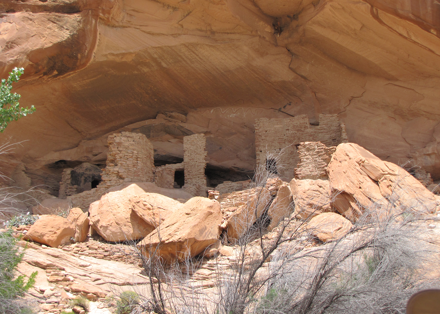
Day 2: Our trip begins at Sand Island, a few miles from the historic Mormon town of Bluff, Utah. The rust-colored cliffs at Sand Island, with their plainly visible petroglyphs and pictographs, provide our first look at Ancestral Puebloan rock art. Once underway, we'll encounter the famous Butler Wash petroglyph panel, which features one of the largest concentrations of rock art in the Southwest. A short hike from the river will bring us to a number of well-preserved Ancestral Puebloan cliff dwellings
Day 1: Plan to arrive in Bluff by mid-day for a short hike, then our orientation meeting will take place at a hotel in the late afternoon. Details about the time and place will be sent to you by the leader upon your acceptance of the trip.
Day 2: Our trip begins at Sand Island, a few miles from the historic Mormon town of Bluff, Utah. The rust-colored cliffs at Sand Island, with their plainly visible petroglyphs and pictographs, provide our first look at Ancestral Puebloan rock art. Once underway, we'll encounter the famous Butler Wash petroglyph panel, which features one of the largest concentrations of rock art in the Southwest. A short hike from the river will bring us to a number of well-preserved Ancestral Puebloan cliff dwellings.
Days 3-5: Downstream, the river flows through the Monument Upwarp, a broad, colorful, arched uplift of the earth's crust. A steep gradient keeps the river lively and provides us with several Class II -- and sometimes (depending on water level) Class III -- rapids.
Soon, we pass the small town of Mexican Hat, named for a huge, balanced slab of rock resembling a sombrero. Immediately to the south lies the Navajo Nation and the renowned Monument Valley, the vast, sculpted, colorful landscape synonymous with John Wayne's Westerns. To the north lies the exotic Valley of the Gods and the looming Cedar Mesa.
After Mexican Hat, the river enters a series of sinuous, 2,000-foot-deep U-turns known as the Goosenecks. Throughout this section of the river, quiet floating alternates with Class II rapids and many smaller riffles. Ravens and raptors soar overhead, while ducks, geese, bighorn sheep, and deer may be seen along the river's edge.
Below the Goosenecks, we encounter a series of long, deep, narrow side canyons that drain the southwest flank of Cedar Mesa. The most remarkable of these side canyons (John's, Slickhorn, and Grand Gulch) contain springs, pools, hanging gardens, and Ancestral Puebloan rock art and ruins. We explore these canyons as much as time and weather permit.
Day 6: On our final day, we float below Grand Gulch to the backwaters of Lake Powell and our take-out point at historic Clay Hills Crossing. After our gear is unloaded, we return to Bluff by van.
Please note, the trip price does not include gratuities for the river guides. Gratuities are entirely voluntary and solely at your discretion, but they are customary. The guides work hard day and night to make this trip as memorable and fulfilling for you as possible. If you agree they worked hard and contributed significantly to the success and enjoyment of your outing, you may want to express your appreciation with a tip. A guideline of 9-18% of the trip price per guest is appropriate. Your Sierra Club trip leader does not share any portion of the gratuity; leaders are unpaid volunteers and cannot accept them.
Logistics
Getting There
You are responsible for getting to our meeting place in Bluff, Utah. If you are flying, the nearest airports are in Grand Junction and Durango, Colorado; Flagstaff, Arizona; and Farmington, New Mexico. However, it is usually less expensive to fly to Las Vegas, Nevada; Phoenix, Arizona; Albuquerque, New Mexico; or Salt Lake City, Utah. In any case, you'll need to drive from the airport to Bluff. The drive to Bluff from any direction is incredibly scenic, and well worth extra vacation time before or after the trip
Getting There
You are responsible for getting to our meeting place in Bluff, Utah. If you are flying, the nearest airports are in Grand Junction and Durango, Colorado; Flagstaff, Arizona; and Farmington, New Mexico. However, it is usually less expensive to fly to Las Vegas, Nevada; Phoenix, Arizona; Albuquerque, New Mexico; or Salt Lake City, Utah. In any case, you'll need to drive from the airport to Bluff. The drive to Bluff from any direction is incredibly scenic, and well worth extra vacation time before or after the trip.
We return to Bluff via van late in the afternoon of our last day. Please plan to stay in Bluff that evening for our farewell no-host dinner. Circumstances may cause a late return to Bluff, so avoid making travel plans for that evening.
Please do not make non-refundable travel arrangements until notified to do so by the trip leader.
Accommodations and Food
You don't have to cook! All meals from lunch on the first day through lunch on the last day are provided. Please indicate any dietary issues on the participant approval questionnaire for each member of your family. We'll try to accommodate most dietary requirements, but you must notify the trip leader in advance.
Beverages will be provided including drinking water, lemonade, coffee, tea, and hot chocolate. You may wish to bring your own sodas or other favorite beverages in plastic bottles, cans, or wine boxes. No glass is allowed on the river trip and no alcohol is allowed during the day or while on the river. This is for your safety, and the safety and enjoyment of others.
You are expected to assist in loading and unloading duffels and other equipment on and off the rafts, and in carrying them to and from the campsites.
We follow Leave No Trace guidelines for desert river corridors to minimize our impact on this fragile environment, including using chemical toilets for solid human waste. There will be no plumbed or pit toilets available on the river.
Trip Difficulty
This is not considered a difficult trip -- the San Juan River is usually a Class II run -- but some fine rapids and many fun "sand waves" keep the trip interesting and the boat crew alert. The trip is run in spring and early summer because water levels depend on snowmelt from the San Juan Mountains northwest of Bluff. The pace of the trip will be leisurely, allowing time for swimming, hiking, photography, and exploring. This is a great trip for first-time river runners and experienced canyon-country aficionados alike.
Although we make every effort to ensure a safe trip and have an excellent safety record, whitewater rafting, hiking, and wilderness travel involve risks and challenges. You must be in good health and willing to participate in trip chores and activities. Please contact the trip leader if you have any concerns about whether this trip is appropriate for you or your family members. The minimum age for this trip is eight years.
We use professional raft outfitters and guides for our raft trips. The industry practice is that outfitters require participants to sign a waiver similar to the Sierra Club waiver you will be asked to sign. Your trip leader will provide you with the details for your trip. For more details, see the Liability Release and Assumption of Risk link at the end of this brochure.
Equipment and Clothing
Spring weather can sometimes be unpredictable, but daytime temperatures typically range from 60-95 degrees. Nighttime lows will be in the 60s. Spring rains are possible and can cool things down considerably. Appropriate attire and equipment will be discussed in later communications.
You will receive an itemized equipment list once you're accepted onto the trip. Rental camping equipment is available from our outfitter. If you bring your own tent, it should be self-supporting with a removable rain fly. Little else is necessary beyond your personal items.
References
Even a rudimentary grasp of the natural and human history of the San Juan region will greatly enhance your experience. The following books are especially recommended:
- Kearsley, Lisa, San Juan River Guide, 3rd ed. This spiral-bound, waterproof guidebook includes geology, biology, and points of interest along with maps of the river and rapids.
- Aton, James M. and Robert S. McPherson, River Flowing from the Sunrise: An Environmental History of the Lower San Juan. Filled with historic photographs and stories people who impacted the river, this book documents the joys and challenges of living in this harshly beautiful place.
- Zwinger, Ann, Wind in the Rock: The Canyonlands of Southeastern Utah. Observations of an award-winning naturalist on the region of the San Juan.
- Roberts, David, In Search of the Old Ones: Exploring the Anasazi World of the Southwest. A good introduction to what is known about the Ancestral Puebloans and their mysterious disappearance.
- Abbey, Edward, Desert Solitaire. Abbey's all-time bestseller, and the book that put "canyon country" on everybody's map.
- Trimble, Stephen and Terry Tempest Williams, Testimony: Writers of the West Speak Out on Behalf of Utah Wilderness. An extraordinary, historic statement on behalf of wilderness, Testimony is a powerful collection by 21 of today's most prominent writers. Originally created as a limited edition presented to Congress, this book is the result of an effort to communicate through art the urgent need to preserve threatened lands.
Conservation
In the words of the late Wallace Stegner, "The Utah deserts and plateaus and canyons are not a country of big returns, but a country of spiritual healing, incomparable for contemplation, meditation, solitude, quiet, awe, peace of mind and body." In addition to river running, we discuss canyon country's most pressing conservation issues -- mining and fracking threats to the area, water allocation in the Colorado Plateau, and the ongoing struggle for a comprehensive wilderness bill for Utah.
The Bears Ears National Monument was initially created by an Executive Order by President Obama in 2016. President Trump reduced the protected acreage by 85% in 2017. This reduction has allowed mining claims and continued looting and vandalism of ancient artifacts. The Biden administration restored the monument to its original size in 2021. We will learn more about the latest challenges to Bears Ears as we journey through this protected area.
Sierra Club National Outings is an equal-opportunity provider and when applicable will operate under permits obtained from U.S. federal land agencies.
Staff


Important Notes
- Carbon Offsets
- Carpooling
- Electronic Billing and Forms
- Electronic Devices
- Equipment
- Essential Eligibility Criteria
- How to Apply for a Trip
- Leader Gratuities
- Medical Issues
- Non-discrimination Statement
- Participant Agreement
- Seller of Travel Disclosure
- Single Supplements
- Terms and Conditions
- Travel Insurance
- Trip Feedback
- Trip Price
- Wilderness Manners