Autumn Colors and Starry Nights: Grand Canyon National Park, Arizona
Sierra Club Outings Trip | Backpack
Highlights
- Trek 50 undulating miles through the Grand Canyon
- Photograph vibrant fall colors with low-angled sunlight
- Explore the Canyon during a quiet season
Includes
-
Camaraderie and adventure
-
Meals and cooking equipment
-
Permits and expert guidance
Overview
The Trip
A backcountry permit cannot be obtained until four months before the trip start date per Grand Canyon National Park rules. Trip dates and itinerary may change to get the permit.
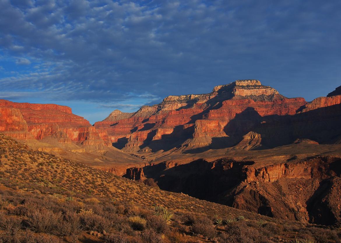
The Canyon is quiet and the air is still and soft in the fall. The searing heat of summer has passed and winter storms are still a month or two away. The leaves of the cottonwoods, tucked into side canyons, glow with a luminous yellow and gold color. The sweeping vistas from the Tonto, in all directions, are particularly fine. The sun is low in the sky, deepening the dramatic red colors, and casting shadows that emphasize the grandeur of the Canyon. This is the best time, maybe the only time, during the year to enjoy this route. At other times it is too hot or too crowded, or there is too much snow on the Rim
The Trip
A backcountry permit cannot be obtained until four months before the trip start date per Grand Canyon National Park rules. Trip dates and itinerary may change to get the permit.
The Canyon is quiet and the air is still and soft in the fall. The searing heat of summer has passed and winter storms are still a month or two away. The leaves of the cottonwoods, tucked into side canyons, glow with a luminous yellow and gold color. The sweeping vistas from the Tonto, in all directions, are particularly fine. The sun is low in the sky, deepening the dramatic red colors, and casting shadows that emphasize the grandeur of the Canyon. This is the best time, maybe the only time, during the year to enjoy this route. At other times it is too hot or too crowded, or there is too much snow on the Rim. We are hiking in the short window from about mid-November to mid-December when the summer crowds have left, it is not too difficult to get a permit, and the weather is still very pleasant.
It is not an accident that Grand Canyon Village developed in its current location or that a hotel was built at the top of the Grandview and a luxury tent camp at the bottom of the Hermit Trail. Views from these locations are unsurpassed. Teddy Roosevelt was not looking at the Canyon from a remote location when he declared the Grand Canyon a National Monument in 1908; he was looking at the Canyon from the Grand Canyon Village area. We will have the unique opportunity to enjoy historic trails and locations that made the Grand Canyon the iconic American landmark that people from around the world enjoy today.
About 13,000 years ago, humans made their first impressions in the Grand Canyon. Garcia Lopez de Cardenas and his men were the first Europeans to glimpse the Canyon from the South Rim in 1540. John Wesley Powell's exploration of the Colorado River in 1869 led prospectors, railroad men, and promoters to dream of ways to turn the wonders of the Grand Canyon into personal fortunes. Colorful characters like John Hance, Louis Boucher, and William Bass were all trying to make their fortunes through prospecting and guiding tourists at the end of the 19th century. Yet not until after World War II did hikers begin to seek out the area's beauty and solitude. Harvey Butchart and his family came to Flagstaff during the postwar period to teach mathematics at Northern Arizona University. He discovered the joys and challenges of the Grand Canyon and for the next 40 years spent much of his free time exploring the backcountry of this fabulous place. His routes, maps, and notes opened the Canyon to a myriad of hikers, like us. Colin Fletcher in his 1968 book, The Man Who Walked Through Time, inspired a generation of backpackers to hike in the Canyon.
The weather is usually cool, crisp, and dry this time of year, but rain and even snow are possible. Usually pleasant during the day (mid-60s) and cooler at night (low 40s), the weather could be ideal for keeping a refreshingly brisk backpacking pace. However, Canyon weather can vary significantly, and be hotter, colder, windier, and wetter than expected.
Itinerary
During the week, we will cover approximately 50 miles on trail and an optional handful of miles off trail. Distances covered each day will range from 3.5 to 12 miles. However, miles in the canyon do not tell the full story. Water is scarce; therefore, many days will require carrying the weight of three or four liters of water. Our pace will be moderate to allow time to appreciate, relish, and photograph the beautiful country through which we will pass.
On a typical day, we will rise early, enjoy a simple breakfast, break camp, and hit the trail to take advantage of available daylight. Some days we will be at camp by mid-afternoon, giving time to explore and prepare for lovely sunset photographs. On other days we may not get to camp until dusk, which will be about 5:30 p.m.
During the week, we will cover approximately 50 miles on trail and an optional handful of miles off trail. Distances covered each day will range from 3.5 to 12 miles. However, miles in the canyon do not tell the full story. Water is scarce; therefore, many days will require carrying the weight of three or four liters of water. Our pace will be moderate to allow time to appreciate, relish, and photograph the beautiful country through which we will pass.
On a typical day, we will rise early, enjoy a simple breakfast, break camp, and hit the trail to take advantage of available daylight. Some days we will be at camp by mid-afternoon, giving time to explore and prepare for lovely sunset photographs. On other days we may not get to camp until dusk, which will be about 5:30 p.m..
The following is our itinerary for the week. Consider it approximate as weather, the group’s pace, and the National Park Service’s permitting requirements may necessitate modifications.
Day 1: We will meet at the Backcountry Information Center at 7 a.m. to do a car shuttle and caravan to our trailhead at Grandview. We will use the Grandview Trail to descend to Horseshoe Mesa, where we may drop packs to explore the caverns of the Cave of the Domes. Next, we drop off the Mesa to Cottonwood Creek on the Tonto Platform, the level where we will be hiking for the majority of the week. Total mileage is only 4.5 miles but we descend 3,500 feet in that short distance. (Breakfast not included.)
Day 2: Our goal today is Grapevine, 5.5 miles away with only minor undulations between. We may drop packs partway to explore an old route to the Colorado River or, once in camp at Grapevine, we may hike down the creek as far as the remaining daylight allows. Hiking down Grapevine offers wonderful sights and fun obstacles.
Day 3: Today we hike to Lone Tree Canyon, named for the lone tree that marks a reliable spring. Mileage is 8.7 miles, much of which is spent traversing from one side to the other of the enormous Grapevine Canyon. If time permits, we may hike to the Lone Tree or you may relax on one of the many welcoming slabs of sandstone beside the trickling creek.
Day 4: Now that our legs are warmed up and packs are getting lighter, we tackle a 10-mile day that includes many ups and downs as we come through Cremation Canyon and up to the South Kaibab Trail. There, we continue on the Tonto to Havasupai Garden where we will camp. If time permits, we may trot out to Plateau Point for a grand view of the Inner Gorge.
Day 5: Our hike today is 12.5 miles and ends at Granite Rapids where we will camp in the dunes adjacent to roaring rapids. A beach camp and swimming in the Colorado River are two of the trip’s highlights.
Day 6: Today is our last day on the Tonto. We will hike a short distance to Hermit Creek, just 5 miles, set up camp, and then hike another 1.5 miles down the beautiful and riparian Hermit Creek to the Colorado River. We can relax for the afternoon while listening to Hermit Rapids, swimming, and playing in the sand.
Day 7: Our last day of the trip is all uphill, 8.2 miles up the historical Hermit Trail. Overall, we will gain over 4000 feet. The Hermit Trail is a. Overall, we will gain over 4000 feet. The Hermit Trail is a mixture of intense bursts of climbing followed by long and gentle traverses. Shortly after passing Santa Maria Spring, we begin our final climb up the switchbacks through the Coconino and Kaibab layers. Many fossils are to be seen in this section. Once on top, we will use the cars we left at Hermit to retrieve our remaining vehicles at Grandview, where we started our trip.
Logistics
Getting There
Plan to arrive at the South Rim by 4:30 p.m. the afternoon before the trip begins. We will meet for dinner (not included), and then have a pre-trip briefing and distribute group gear and food. On the last day of our trip, we intend to return to the South Rim by 2 p.m., although delays are possible.
If you wish to stay at one of the Grand Canyon Village lodges, make your lodging reservations promptly as they are popular. There is also Mather Campground in the Village, but camping at the rim can be quite cold this time of year. Just south of the Village, in Tusayan, there are more lodging options. See http://www.nps.gov/grca/planyourvisit/eatingsleeping.htm for lodging and camping options at or near Grand Canyon Village
Getting There
Plan to arrive at the South Rim by 4:30 p.m. the afternoon before the trip begins. We will meet for dinner (not included), and then have a pre-trip briefing and distribute group gear and food. On the last day of our trip, we intend to return to the South Rim by 2 p.m., although delays are possible.
If you wish to stay at one of the Grand Canyon Village lodges, make your lodging reservations promptly as they are popular. There is also Mather Campground in the Village, but camping at the rim can be quite cold this time of year. Just south of the Village, in Tusayan, there are more lodging options. See http://www.nps.gov/grca/planyourvisit/eatingsleeping.htm for lodging and camping options at or near Grand Canyon Village.
The Grand Canyon Village at the South Rim is located about 75 miles from Flagstaff, AZ, 180 miles from Phoenix, AZ, and 270 miles from Las Vegas, NV. Regular flights are available to all three airports. Ground shuttles are available from Flagstaff or Phoenix to the Village. See http://www.arizonashuttle.com/ for information. Please do not make non-refundable travel arrangements until notified to do so by the trip leader.
Accommodations and Food
Our first provided meal will be lunch on our first day and the last meal will be lunch on our final day. Responsibility for cooking and clean-up will be shared by trip participants. Meals include hearty, healthy, and varying breakfasts, lunches, and dinners. These meals are vegetarian with some optional meat available occasionally. The leaders work hard to make the weight of the food as light as possible to lessen the loads in our packs.
Trip Difficulty
We cover 50 miles with packs and must descend and ascend almost 4,000 feet to get into the Canyon and back out. In between there is plenty of more minor up and down hiking that will keep our heart rates up. Our average daily distance is about seven miles, mostly on a good trail. We will also do about 10 to 15 miles of optional day hiking without heavy packs during the week. Most of the hiking is straightforward, but there is arduous hiking as well. All backpack trips are challenging, and Grand Canyon backpack trips can be especially demanding because of dramatic elevation changes, unstable footing, steep trails, and potentially hot conditions. This trip is rated moderate to strenuous (Level 4). There may be sections that feel more like a strenuous outing (Level 5), especially descending into and ascending out of the Canyon, and stretches along the Tonto that feel more like a moderate hike (Level 3). Because of the rating, participants must be committed to seriously training for this outing for a minimum of two months and preferably three months before the start of the trip. The leaders will gladly share a training routine that has been successful for others on Grand Canyon trips. Overall, this trip on average, is at the easier end of a 4 rating compared to the Sierra Club’s other Grand Canyon backpack trips.
Equipment and Clothing
The Sierra Club provides cooking gear, food, water purification, and a first-aid kit to be used for emergencies only. You are responsible for everything else that you want/need. We divvy up the gear and food provided by the Club, which generally equates to approximately 11-12 pounds each at the start of the trip. Your backpack needs to have enough capacity for this extra gear, which will be the size of approximately two one-gallon milk cartons. A 60-liter pack is sufficient.
We strongly discourage anyone from bringing an overloaded pack. This trip will be safer, easier, and more enjoyable if you keep your pack weight to a minimum. Trip participants will be required to keep their pack weight to 42 pounds or less. This weight includes all personal gear, group food/gear, and water. We will work with everyone to pack light and will provide participants with a comprehensive gear list along with recommendations.
For water purification, we will use Micropur chlorine tablets or boiling. Tablets can be provided for the purification of personal drinking water. Because many participants do not like the chlorine taste, they often bring their method to purify drinking water.
References
-
For an overview of the Grand Canyon, the Trails Illustrated Grand Canyon East: Grand Canyon National Park map is good. Available online from many sources.
-
For detailed coverage, the U.S.G.S. 7.5-minute topographical maps have all the details. These are not required but are perfect for the map enthusiast. Maps that cover our route include Cape Royal, Phantom Ranch, and Grand Canyon Quadrangles, all in AZ. Leaders will carry a set of these on the trip and are happy to share.
-
Fedarko, Kevin, Emerald Mile. 2013. An amazing and unique river adventure.
-
Ranney, Wayne, Carving Grand Canyon (2nd ed). Grand Canyon Association, 2012. Read about how the Grand Canyon may have come into existence.
-
Davis, Wade, River Notes: A Natural & Human History of the Colorado. Island Press, 2012. This is an excellent summary of how the once mighty and majestic Colorado became the dammed and highly regulated river that it is today.
-
Osborne, Sophie A. H., Condors in Canyon Country: The Return of the California Condor to the Grand Canyon Region. Grand Canyon Association, 2008. An epic attempt to save a great bird.
-
Price, L. Greer, An Introduction to Grand Canyon Geology. Grand Canyon Association, 1999. An accessible book with plenty of illustrations and photos about Grand Canyon geology.
-
Anderson, Michael F., Living at the Edge. Grand Canyon Association, 1998. A book about the colorful pioneering people of European descent who first explored and settled in the Grand Canyon.
-
Huisinga, Ann, Lori Makarick and Kate Watters, River and Desert Plants of the Grand Canyon. Mountain Press Publishing, 2006. A great reference for the common shrubs, trees, and flowers of the Inner Canyon.
-
The Grand Canyon Association is a great resource with many books of interest: http://www.grandcanyon.org/
-
The National Park Service maintains a website for each national park. The website for the Grand Canyon is especially complete, up-to-date, modern (podcasts, webcams), and informative. Regularly visit http://www.nps.gov/grca for information or just to look around.
Conservation
Staff


Important Notes
- Carbon Offsets
- Carpooling
- Electronic Billing and Forms
- Electronic Devices
- Equipment
- Essential Eligibility Criteria
- How to Apply for a Trip
- Leader Gratuities
- Medical Issues
- Non-discrimination Statement
- Participant Agreement
- Seller of Travel Disclosure
- Single Supplements
- Terms and Conditions
- Travel Insurance
- Trip Feedback
- Trip Price
- Wilderness Manners