Current River Canoeing, Ozark National Scenic Riverways, Missouri
Sierra Club Outings Trip | Canoe
Highlights
- Canoe/camp on a crystal-clear, spring-fed Ozark river
- Enjoy rock bluffs, caves, bubbling springs & wildlife
- Join a 2013 Boston Globe "Top 5 Sierra Club Trip"
Includes
-
Canoe rental, paddles, PFDs, and group gear
-
Shuttle to put-in/take-out and camp fees
-
Restaurant dinner Day 1; breakfasts & dinners each day
Overview
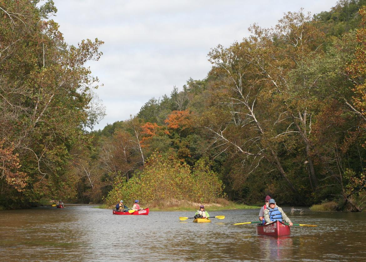
The Trip
A classic October Current River canoe trip in the Missouri Ozarks. We will spend four leisurely days canoeing and camping 35 miles of the clear, spring-fed Current River. Each day offers opportunities to relax, fish, photograph, and take scenic side hikes.
The Ozark National Scenic Riverways (ONSR), established by an act of Congress in August 1964, is the first national park to protect a wild river system. The 80,000-acre national park stretches 134 miles along both the Current and Jacks Fork rivers. Montauk Springs form the headwaters of the Current River
The Trip
A classic October Current River canoe trip in the Missouri Ozarks. We will spend four leisurely days canoeing and camping 35 miles of the clear, spring-fed Current River. Each day offers opportunities to relax, fish, photograph, and take scenic side hikes.
The Ozark National Scenic Riverways (ONSR), established by an act of Congress in August 1964, is the first national park to protect a wild river system. The 80,000-acre national park stretches 134 miles along both the Current and Jacks Fork rivers. Montauk Springs form the headwaters of the Current River.
Canoe rental, paddles, PFDs, shuttle, permits, most meals, and other expenses are included. Kayaks will not be used due to the need to carry food and other group gear. Novice paddlers and families are welcome. The minimum age for children accompanied by a parent is 16 years old, but the leaders will be happy to talk with the parents to discuss participation of children under 16 years old.
Due to the need to confirm shuttle and canoe rental reservations, sign-ups are needed by or before September 12, 2018.
Itinerary
About 14 days before Day 1: You’ll attend a mandatory Trailhead Talk conference call from the comfort of your home. We will discuss logistics, expectations, food, gear, etc. Expect the call to last approximately 45 minutes and bring questions or concerns.
Day 1: (Rally Day) Participants are to meet by 1:00 p.m. at the outfitter's campground south of Salem, Missouri. If necessary, trips can be made into Salem to purchase gear, additional supplies, or forgotten items. Once we’ve all arrived, we’ll drive to the newly opened Echo Bluff State Park. We can visit Echo Bluff, see Sinking Creek, and have a restaurant dinner (included in trip price). After dinner we’ll return to the outfitter’s campground and enjoy a campfire. We’ll leave our vehicles at the outfitter’s campground for the duration of the trip
About 14 days before Day 1: You’ll attend a mandatory Trailhead Talk conference call from the comfort of your home. We will discuss logistics, expectations, food, gear, etc. Expect the call to last approximately 45 minutes and bring questions or concerns.
Day 1: (Rally Day) Participants are to meet by 1:00 p.m. at the outfitter's campground south of Salem, Missouri. If necessary, trips can be made into Salem to purchase gear, additional supplies, or forgotten items. Once we’ve all arrived, we’ll drive to the newly opened Echo Bluff State Park. We can visit Echo Bluff, see Sinking Creek, and have a restaurant dinner (included in trip price). After dinner we’ll return to the outfitter’s campground and enjoy a campfire. We’ll leave our vehicles at the outfitter’s campground for the duration of the trip.
Day 2: (Baptist Camp Access to Cedar Grove) Today we start our adventure, traveling light! The outfitter will shuttle us, the canoes, and our day gear to Baptist Camp Access. This stretch of primitive, twisty river is a blue-ribbon trophy trout area (check the fishing regulations). We’ll side hike to John & Susie Nichols’ hardscrabble farmstead worked from 1910 to 1959. We’ll also hike up to visit the Lower Parker School in continual use between 1905 to 1955. At Cedar Grove we’ll make the only portage of the trip and make camp on a large gravel bar just down-stream of the low water dam. The outfitter will meet us at Cedar Grove and deliver the rest of our personal and group gear. Cedar Grove only has basic amenities: pit toilets, tables, and fire grills.
Day 3: (Cedar Grove to Aker’s Ferry) From Cedar Grove we’ll paddle a white-ribbon trout section to Aker's Ferry. We’ll stop at Welch Spring and view the ruins of the Welch Spring Hospital. In 1913 Illinois doctor C.H. Diehl bought Welch Spring for $800 and built a hospital and resort, believing that the spring water and pollen-free cave air would heal people with asthma, emphysema, and tuberculosis. When Dr. Diehl died in 1945 his project was being referred to as "Diehl's Folly." We can cross the river to visit Maggard’s Cabin, located downriver from Welch Spring. We’ll camp near Aker’s Ferry, the Current River’s final operating ferry. After setting up camp, we can hike to the Aker’s Ferry General Store to purchase ice cream, sodas, souvenirs, or necessities. This evening we may be joined by a National Park Service interpretative ranger who can educate us about the Ozark National Scenic Riverways and the Park Service’s current projects, the region’s history, flora and fauna, and answer our questions. Aker’s Ferry campsite has basic amenities: pit toilets, tables, and fire grills.
Day 4: (Aker’s Ferry to Pulltite) From Aker’s Ferry we’ll paddle to Pulltite. Along the route today is Troublesome Hollow, the "Pothole," and Rock House Cave (aka Meeting House Cave). Both armies used Meeting House Cave as a hideout during the Civil War. We’ll canoe to Cave Spring Cave (average flow of 24 million gallons/day) and we can hike up the Cave Spring Trail to the Devil’s Well. A Native American dugout canoe was discovered on the bottom of the Cave Spring. We’ll camp at the Pulltite Spring Campground facility and we can hike the campground nature trail, look for ripe persimmons and paw-paws, and perhaps visit the hilltop Weese cemetery. This evening the Missouri Sierra Club’s Ozarks Conservation Program Coordinator may join us to talk to us about the conservation issues affecting the Ozark National Scenic Riverways. Pulltite has electricity, indoor toilets and hot showers, RV dump stations, electric hook-ups, reservation systems, and campground hosts.
Day 5: (Pulltite to Round Springs) After breaking camp we’ll cross the river to visit the Pulltite Spring, a clear, aqua-blue spring lush with watercress and aquatic plants. The Pulltite Cabin is just down the trail from Pulltite Spring. The cabin was constructed in the "French-style" around a massive fireplace and finished Thanksgiving 1913. Moving on down river, there are more caves (Shelter Cave, Merritt Rock Cave, Bat Cave, Hole in the Rock), more springs (Fire Hydrant Spring and Sand Boil Spring), Sinking Creek and more opportunities to fish. We’ll take out at Round Spring. We can view Round Spring, a deep-blue spring that produces 33 million gallons of water per day. Local legend says one foggy Ozark night a wagon crashed into the spring; in 1978, divers discovered wagon wheels 55 feet down. We’ll be met by our canoe outfitter at Round Spring and shuttled back to the outfitter’s campground to our vehicles and prepare for our journey home.
Logistics
Getting There
The closest airport is in St. Louis. It is 127 miles -- a two-hour drive. The leaders will not be providing transportation to the outfitter’s campground. Carpooling is encouraged. The leaders cannot arrange carpooling, but participants will be given opportunities to arrange carpooling amongst themselves.
Please do not make non-refundable travel arrangements until notified to do so by the trip leader.
Accommodations and Food
Accommodations while on the river are primitive with little or no development. This trip is self-contained and each night we’ll be tent camping. Campground amenities are described above. Participants are expected to assist with camp chores on a rotating basis, including collecting firewood and assisting in meal preparation and kitchen clean-up
Getting There
The closest airport is in St. Louis. It is 127 miles -- a two-hour drive. The leaders will not be providing transportation to the outfitter’s campground. Carpooling is encouraged. The leaders cannot arrange carpooling, but participants will be given opportunities to arrange carpooling amongst themselves.
Please do not make non-refundable travel arrangements until notified to do so by the trip leader.
Accommodations and Food
Accommodations while on the river are primitive with little or no development. This trip is self-contained and each night we’ll be tent camping. Campground amenities are described above. Participants are expected to assist with camp chores on a rotating basis, including collecting firewood and assisting in meal preparation and kitchen clean-up.
Much of the Current River country is remote without cell phone service, but there are public campgrounds with phones along the way. We’ll be traveling during the off-season and most days we will have the river all to ourselves.
The first meal provided will be the dinner at the Echo Bluff restaurant and the last meal will be breakfast on day five. Lunches are not provided.
Please discuss food allergies, dietary restrictions, or special food requests with the leaders before signing up for the trip. Pre-trip, the leaders will distribute a tentative menu and solicit input from the participants. Speak up! The leaders will not provide lunches, trail snacks, between meal snacks, or alcohol. For safety reasons, the leaders discourage alcohol use during the trip.
Meals may include meat -- perhaps even fresh trout, dairy, and eggs. We will do our best to accommodate vegetarians and those with medical dietary restrictions. Please contact the leader if you require dietary accommodation. Participants with especially challenging food restrictions may be asked to bring or prepare their own food.
Trip Difficulty
The Current River is rated as a Class 1 river and a Class 2 in specific places. Overall it is not a deep river. We will be paddling 3-5 hours per day with frequent breaks or side hikes.
Participants should also have experience with canoe camping (i.e. both canoeing and camping). Basic to intermediate paddling skills are required. Experienced and intermediate paddlers may find it easy but beginning or novice paddlers could find the river challenging. Participants must be able to manage -- with teamwork -- a canoe in at least light wind, small waves, or fast shoal water. Do not hesitate to ask the leaders for advice or for a demonstration of paddle strokes. The leaders will initially pair paddlers into paddle teams based upon their self-reported skill levels.
Historically, the average high temperature is 74º and the average low is 53º with a range of 32º to 83º. We will watch the weather and river forecasts, but be prepared for a possible extreme of warm and cool temperatures.
Although we will do our very best to adhere to the schedule listed above, the itinerary is subject to change for numerous reasons beyond our control. Selection of the final itinerary and paddling route is left up to the discretion of the leaders in consideration of each participant’s physical condition and skills, and weather conditions. As needed, the leaders will adjust the trip itinerary based on the capabilities and experience of the group. This trip is operated rain or shine; however, the trip may be cancelled in the event of current or imminent flooding conditions. Travel insurance is recommended and is available through the Sierra Club (see “Notes for Sierra Club Outings” below).
Equipment and Clothing
Participants should bring basic camping gear (tent, sleeping bag, pad, proper clothing, water bottles, small cooler) in addition to any canoeing or fishing gear. After registration and approval, the leader will provide a detailed required and optional gear list, which does contain some specialized equipment. The leaders will provide food, water, stoves, cooking gear, and other group gear. A list of leader-provided group gear will be sent to approved participants.
If you want to fish, you will need a fishing license and trout permit. These can be purchased locally or online at https://huntfish.mdc.mo.gov/fishing/permits?field_rel_species_nid=78.
Land Use Restrictions: The National Park Service prohibits glass containers on the rivers within the park boundary. Additionally, all forms of polystyrene foods and beverage coolers often marketed under the name "Styrofoam" is not allowed. Participants are encouraged to pick up litter when it can be done safely. The outfitter will provide mesh litterbags. We will pack out our trash or dispose of it in trash bins at the campsites.
The National Park Service prohibits jumping from cliffs and bluffs and using rope swings. Cliff jumping is a serious safety issue that also impacts the fragile vegetation growing in thin soils on the glades.
Additional Land Use Restrictions are at https://www.nps.gov/ozar/learn/news/controlling-rowdiness-on-the-rivers.htm
The NPS has closed all caves for exploration along our route due to the discovery of White Nose Syndrome (WNS). WNS is a disease that is 90% fatal to bats but doesn't affect humans. The disease and its transmission are currently under research, but it is thought that humans may carry the disease spores. For more about WNS, go to: https://www.whitenosesyndrome.org/ or http://www.nps.gov/ozar/naturescience/cave.htm
References
- Kohler, Steve and Oliver Churchyard, Two Ozark Rivers: The Current and the Jacks Fork.
- Topographical maps of the trip route. Purchase these quad maps: Montauk, Cedar grove, Lewis Hollow, Round Spring, The Sinks, and Eminence.
- Montauk, Missouri Topographic Map: https://www.topoquest.com/map-detail.php?usgs_cell_id=29905
- National Park Service ONSR: http://www.nps.gov/ozar/index.htm
- National Park Service ONSR History & Culture: http://www.nps.gov/ozar/historyculture/index.htm
- Montauk State Park: https://mostateparks.com/park/montauk-state-park
- Missouri Dept. of Conservation fishing information: http://mdc.mo.gov/fishing
- Current River information: http://www.missouricanoe.org/
- Ozark Caves: http://www.ozarkcaving.com
- Devils’ Well: http://www.nps.gov/ozar/planyourvisit/devils-well.htm
- Devils’ Well Exploration: http://www.thesalemnewsonline.com/news/article_dfc35c84-23e4-11e5-b4b2-ebbdb153ddb3.html
- Tandem Canoe Basics: https://www.youtube.com/watch?v=rjdlF7Cnr3E
- How to Do a J-Stroke - Canoe Technique: https://www.youtube.com/watch?NR=1&v=kSOu0jyuqN8&feature=endscreen
- "How Rivers Get Their Curves, The Answer Is Both Simple And Fascinating": http://news.distractify.com/megan-mccormick/curvy-rivers-explained/?v=1
Conservation
ONSR celebrated its 50th anniversary on August 27, 2014. In November 2013, the National Park Service issued a draft Management Plan. It was the first plan update and it will be in effect for the next 20 years. In January 2015, the National Park Service issued its Record of Decision for its new General Management Plan, Wilderness Study, and Environmental Impact Statement.
The National Park Service recommended Alternative B and while Sierra Club’s Missouri Chapter was supportive of Alternative B, it also very active and vocal in gathering public input for Alternative A. The Park received 3,094 comments about the proposed management plan — 83 percent of them from Missouri residents. Four public open house meetings drew 1,450 people.
The National Park Service recommended and eventually chose a revised Alternative B:
- It allows no greater than 25 hp powerboats on the Upper Current from the beginning of gigging season to the end of trapping season. Those areas would be closed to powerboats during the busy canoe and kayaking months;
- It allows powerboat engines up to 150 hp on the Lower Current River;
- It allows camping on gravel bars by paddlers and boaters, as long as their campsite is a 1/2 mile away from a designated campground and at least 50 feet away from any designated river access;
- It eliminates many unofficial horse trails but increased the amount of designated horse trails by additional 25 miles to a total of 45 miles. The remaining undesignated horse trails will be restored to natural conditions;
- It closes vehicle access to some gravel bar camping areas. The National Park Service plans to designate gravel bar camping areas and/or campsites that can be reached by cars or trucks.
The National Park Service made a commitment to develop and implement a roads and trails management plan and to also evaluate road ownership with the ONSR to ensure consistency with NPS objectives. Until a roads and trails management plan is completed, unauthorized trails that pose the greatest threat to park resources and visitor safety could be closed on a case-by-case basis.
The NPS deemed 3,430 acres of the Big Spring tract are suitable for wilderness designation. It now needs designation by Congress.
For more information, contact the Missouri Chapter of the Sierra Club, 7164 Manchester Ave, Maplewood, MO 63143, Email: missouri.chapter@sierraclub.org
Here’s what you can do:
- Come experience firsthand the Current River and the Ozark National Scenic Riverways.
- Ask ONSR to send you information about the management plan or go to http://www.nps.gov/ozar/getinvolved/planning.htm and follow the links for management plan.
- E-mail or write ONSR about your concerns for the Ozark National Scenic Riverways, including urging the completion of a "roads and trail" study to assess which access points (for motorized vehicles or horses) should be closed. Problems with either horses (e.g. horses in the river), ATV/truck traffic on/near the river, or motorized boats upstream from Round Spring during the summer should be reported to ONSR.
- Renew your membership with the Sierra Club and become further involved in conservation.
- Contact the Missouri Sierra Club chapter, discuss and become involved with its efforts to protect ONSR. http://www.sierraclub.org/missouri
- Contact the Friends of the Ozark Riverways and become involved with its efforts to protect ONSR. http://www.friendsofozarkriverways.org/
Sierra Club National Outings is an equal-opportunity provider and when applicable will operate under permits obtained from U.S. federal land agencies.
Staff


Important Notes
- Carbon Offsets
- Carpooling
- Electronic Billing and Forms
- Electronic Devices
- Equipment
- Essential Eligibility Criteria
- How to Apply for a Trip
- Leader Gratuities
- Medical Issues
- Non-discrimination Statement
- Participant Agreement
- Seller of Travel Disclosure
- Single Supplements
- Terms and Conditions
- Travel Insurance
- Trip Feedback
- Trip Price
- Wilderness Manners