Backpacking the Eagle Cap Wilderness: The Eagle Creek Loop, Oregon
Sierra Club Outings Trip | Backpack
Highlights
- Hike and camp among breathtaking mountain scenery
- Experience blue-ribbon trout fishing
- Enjoy one or more layover days
Includes
-
Camping and permit fees
-
Gourmet backcountry meals
-
Group commissary, bear canisters, and cooking gear
Overview
The Trip
Join us as we backpack in one of Oregon’s “Best-kept Hiking Secrets," the Eagle Cap Wilderness, an area located in the Wallowa Mountains of northeastern Oregon in the heart of the Wallowa-Whitman National Forest. Our trip takes place on the southern side of the Wallowa Mountains on the Main Eagle Creek -– West Eagle Creek Loop. It includes a 30-mile route, two layover days, various side trips, granite peaks, high alpine passes, mountain lakes, National Wild and Scenic rivers, clear streams, wildflower-filled meadows, blue-ribbon trout fishing waters, and beauty beyond words. As Douglas Lorain, author of “100 Classic Hikes in Oregon” says: “In fact, there is so much outstanding scenery here that a lifetime would be inadequate to see all of its glories.” So dust off your hiking boots and get ready for an adventure into the Eagle Cap Wilderness
The Trip
Join us as we backpack in one of Oregon’s “Best-kept Hiking Secrets," the Eagle Cap Wilderness, an area located in the Wallowa Mountains of northeastern Oregon in the heart of the Wallowa-Whitman National Forest. Our trip takes place on the southern side of the Wallowa Mountains on the Main Eagle Creek -– West Eagle Creek Loop. It includes a 30-mile route, two layover days, various side trips, granite peaks, high alpine passes, mountain lakes, National Wild and Scenic rivers, clear streams, wildflower-filled meadows, blue-ribbon trout fishing waters, and beauty beyond words. As Douglas Lorain, author of “100 Classic Hikes in Oregon” says: “In fact, there is so much outstanding scenery here that a lifetime would be inadequate to see all of its glories.” So dust off your hiking boots and get ready for an adventure into the Eagle Cap Wilderness!
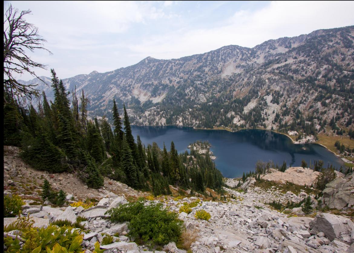
The Eagle Cap Wilderness was established in 1940 and was included in the National Wilderness Preservation System by the Wilderness Act of 1964. The area is comprised of 361,446 acres of wilderness including almost 600 miles of trails. It is the largest wilderness area in Oregon and is considered by many people to be one of the finest backpacking areas in the state.
The area is characterized by high alpine lakes and meadows, bare granite peaks and ridges, and U-shaped glacial valleys. Elevations in the Eagle Cap Wilderness range from approximately 3,000 feet in lower valleys to 9,845 feet at the summit of Sacajawea Peak, with 30 other summits exceeding 8,000 feet. The wilderness holds almost 60 alpine lakes and more than 37 miles of streams.
Additionally, it is home to an abundance of wildlife, including black bears, cougars, deer, elk, bighorn sheep, mountain goats, pika, pine martens, badgers, red diggers (ground squirrels), and marmots. Birds include the peregrine falcon, golden eagle, bald eagle, Ferruginous hawk, Swainson's hawk, and the gray-crowned rosy finch. Many trout inhabit the lakes and streams of this area, making it a fisherman’s paradise!
The plants in the area vary from grasslands and ponderosa pine forest to alpine meadows. Engelmann spruce, larch, mountain hemlock, sub-alpine fir, and whitebark pine are present at higher elevations. The meadows hold varieties of Indian paintbrush, sego lilies, elephanthead, larkspur, shooting star, and bluebells. Tracts of old-growth forest can still be found in the area, too.
The Wallowa Mountains are the ancestral lands of the Nez Perce Indians. They used the area for summertime hunting and huckleberry gathering.
Itinerary
The majority of our trip will be on maintained trails within the national forest. We will also have two layover days with great opportunities for on- and off-trail explorations without the burden of a heavy pack. Our itinerary is tentative and subject to change based on weather and trail conditions along with the ability, health, and fitness levels of other participants in the group. In addition, our itinerary was designed so that it could be flexible based on the interests of the group due to the numerous side trips available in the area
The majority of our trip will be on maintained trails within the national forest. We will also have two layover days with great opportunities for on- and off-trail explorations without the burden of a heavy pack. Our itinerary is tentative and subject to change based on weather and trail conditions along with the ability, health, and fitness levels of other participants in the group. In addition, our itinerary was designed so that it could be flexible based on the interests of the group due to the numerous side trips available in the area.
Day 1: Our group will meet on Saturday, August 20 at Boulder Park Campground in the Wallowa-Whitman National Forest to make camp. The campground is located near the Main Eagle Creek Trailhead, our starting point for the trip. In the evening, we will hold a trip orientation, then socialize around the campfire before turning in for the night.
Day 2: In the morning, we will distribute our group gear and food among the group. Afterward, we will shuttle a few of our vehicles at the West Eagle Trailhead, our exit point on the last day of the trip. When everyone arrives back at the Main Eagle Creek Trailhead (4,910 feet), we will start our backpacking trip down the trail. We will follow Eagle Creek and cross it several times as we ascend the trail to arrive at Eagle Creek Meadow and the junction to the Lookingglass Lake Trail (6,150 feet) at 4.0 miles. We'll see a meadow between the trail and Eagle Creek that has good campsites along the creek; we can either make our campsite there or head another two miles down the Lookingglass Lake Trail to Bear Lake (7,030 feet). There are good campsites on the north side of Bear Lake. If time permits, we can hike off-trail to see Cooper Creek Falls. The total mileage for the day will be either 4.0 miles with a 1,250-foot elevation gain if we camp at Eagle Creek Meadows, or 6.0 miles with an elevation gain of 2,120 feet if we camp at Bear Lake.
Day 3: Today is our first layover day, making it a good time to relax our aching muscles and recharge our batteries! Our options include exploring the three nearby lakes, Bear Lake (7,030 feet), Culver Lake (7,030 feet) or Lookingglass Lake (7,302 feet). All three lakes offer good opportunity for fishing. If you are not a fisherman, some other possible options include swimming in the lakes, searching for nearby wildlife, reading a good book, or hanging back to rest at camp.
Day 4: From Eagle Creek Meadow (6,150 feet), we ascend to the Trail Creek Trail junction (6,880 feet) and turn left. We continue ascending until we arrive at scenic Cached Lake (7,343 feet). There is a lush meadow filled with wildflowers on the northeast side of the lake with several good campsites along trees next to it. From the southwest shore of the lake, there are excellent views of the pyramid-shaped Needle Point (9,018 feet). The total mileage for the day will be either 4.3 miles with a 1,193-foot elevation gain from Eagle Creek Meadow, or 6.3 miles from Bear Lake. If we get to the camp site early enough, we have the option of scrambling to the top of Needle Point (a steep but not technically difficult climb) for outstanding views of the surround area, including the scenic Minam River Canyon to the north.
Day 5: From Cached Lake (7,343 feet), we will ascend 3.1 miles up to an unnamed, but scenic, pass (8,160 feet). There are views of peaks and forested valleys in all directions. Afterward we descend 1.5 miles to the Bench Canyon Trail junction (7,410 feet). In another 1.2 miles, we come to a trail junction (6,240 feet), where the Trail Creek Trail heads to the right and onto the Upper Minam River Trail. However, we head left along the West Fork Eagle Creek Trail. At this point we ascend along the trail where we come up to a meadow that has scenic campsites (6,550 feet) close to two small streams; we will stay there for the night. The total mileage for the day is 6.8 miles with a total elevation gain of 1,127 feet and total elevation loss of 750 feet.
Day 6: As we head west, we start ascending switchbacks for about 4.4 miles before we reach Wonker Pass (8,420 feet). From this spot, there are great views to nearby Traverse and Echo lakes, to Trail Creek Canyon, and to the distant Elkhorn Range. From there, it is a 1.5-mile descent to Traverse Lake (7,720 feet) or another mile down to Echo Lake (7,720 feet). Both lakes have nice campsites with scenic views as well. If we stay at Traverse Lake, our mileage will be 5.9 miles with a 1,870-foot elevation gain and a 700-foot elevation loss. Otherwise, it will be 6.9 miles with a 1,870-foot elevation gain and 1,150-foot elevation loss to get to Echo Lake.
Day 7: Today is our second layover day. As before, there are ample opportunities for fishing and swimming at either Traverse or Echo lakes.
Day 8: Today is the last day of the outing. From our campsite, we will continue down the West Eagle Creek Trail, descending as we work our way to the trailhead where some of our cars are parked. If we camped at Traverse Lake, our mileage would be 6.4 miles with a elevation loss of 2,260 feet. From Echo Lake, it is 5.4 miles to the trailhead with an elevation loss of 1,810 feet. The trip officially ends when we shuttle back to the Main Eagle Creek trailhead to pick up the other vehicles and after everyone returns all the group gear and bear canisters back to the leaders. If any participants are interested, we will meet upon our return to Baker City for optional drinks and a farewell dinner at Barley Brown’s Brew Pub (at your own expense).
Logistics
Getting There
On the first day of the outing, we will meet at the Boulder Park Camp in the Wallowa-Whitman National Forest.
Due to the possibility of unknown circumstances (such as flight delays or lost baggage), please plan to arrive in the area at least a day before the first day of the trip. The backpacking trip begins at the Main Eagle Trailhead and ends at the West Eagle Trailhead in Wallowa-Whitman National Forest. The leader will send out more specific information about our meeting place and time after you have been approved for the trip
Getting There
On the first day of the outing, we will meet at the Boulder Park Camp in the Wallowa-Whitman National Forest.
Due to the possibility of unknown circumstances (such as flight delays or lost baggage), please plan to arrive in the area at least a day before the first day of the trip. The backpacking trip begins at the Main Eagle Trailhead and ends at the West Eagle Trailhead in Wallowa-Whitman National Forest. The leader will send out more specific information about our meeting place and time after you have been approved for the trip.
The nearest airports to the Baker City are Boise, Idaho (130 miles, 2.5 hours) or Portland, Oregon (305 miles, 5 hours). All participants must make their own travel arrangements. Further, participants are responsible for getting themselves to the trailhead on their own. Individuals interested in ride-sharing should contact other trip members once the final roster is put together.
Please do not make travel arrangements until the leader has confirmed you as a trip member.
Accommodations and Food
Many lodging options are available in Baker City, Oregon. Feel free to contact the trip leader for more information on pre- and post-trip lodging.
During the trip, we will be preparing some vegetarian meals, but some of them may contain beef, chicken, or fish. However, we can easily accommodate vegetarians on the days when our meal includes meat. On most nights, our dinners will include hot soup, a main entree, and a dessert. We will provide instant coffee, tea, and hot chocolate during breakfast and dinner. All participants are expected to assist with camp chores, including preparing and cleaning up after a meal, on a rotating basis.
Our first meal will be breakfast at the Boulder Park Camp on Sunday morning. Our last meal will be lunch on the trail on the final day of the trip. At the conclusion of the outing, participants are invited to join the leaders for optional drinks and a farewell dinner at Barley Brown’s Brew Pub in Baker City (at your own expense).
Trip Difficulty
This is a moderate trip covering around 30 trail miles (excluding side trips on layover days) with daily mileage in the range of five to seven miles. Please keep in mind that the trail will follow creeks, rivers, lake basins, meadows, forests, and high ridges, including a climb over two passes. Because we will be hiking in mountainous terrain, there will be sections of the trail that will have steep drop offs. Further, the route will include some significant elevation gains and losses, stream and snowfield crossings, and the possibility of unpredictable weather.
In summer, temperatures can potentially soar into the 90s and then dip to lows in the 40s (depending on the elevation). Participants should come well prepared for sudden changes in the weather and potential afternoon thunderstorms.
This outing is suitable for experienced backpackers or advanced beginners who are fit and have recent backpacking experience. A physical fitness regimen, especially cardiovascular training (beginning at least three months prior to the trip), is highly recommended. Your enjoyment of this backpacking trip will depend on your preparedness, physical conditioning, flexibility, and most importantly, your enthusiasm.
Equipment and Clothing
All group cooking equipment, water purification tablets, bear canisters, group first aid kit, and food will be provided. Each participant will need to bring his or her own personal mess kit that should include an insulated mug, bowl, and spoon.
Summer temperatures are generally warm in the Wallowa Mountains, but the weather can still be unpredictable so you will need to bring warm layers, good quality rain gear, and a tent with a waterproof rain fly. Be sure to bring your swimsuit (lots of lakes for swimming), fishing gear (fantastic stream and lake fishing), binoculars (to search for wildlife), and your camera (to capture excellent scenery). A complete list of required equipment will be sent to all participants once the leader approves them for the trip.
Please try to limit your personal gear to around 25 pounds. Group gear and food will add an additional 10 to 15 pounds of weight to your packs. Your pack will need to hold your personal gear and a bear canister which is about the size of two one-gallon milk jugs. We highly encourage tent sharing whenever possible since it reduces our impact to the camping areas, and most importantly, it decreases the amount of weight that you will be carrying in your backpack.
References
Maps:
Books:
Websites:
• US Forest Service website for the Wallowa-Whitman National Forest: http://www.fs.usda.gov/wallowa-whitman/
Conservation
The Sierra Club is an environmentally focused entity. We are concerned about conservation and sustainability of resources, both locally and globally. Our work is accomplished by volunteers and aided by a salaried staff, and encourages grassroots involvement. Our outings seek to empower participants toward greater understanding, advocacy, and participation in the goals of the Club. During the trip, we will discuss issues impacting the areas in and around the Wallowa-Whitman National Forest. Further, we will follow Leave No Trace practices on this outing.
Sierra Club National Outings is an equal-opportunity provider and will operate under a permit from the Wallowa Whitman National Forest.
Staff


Important Notes
- Carbon Offsets
- Carpooling
- Electronic Billing and Forms
- Electronic Devices
- Equipment
- Essential Eligibility Criteria
- How to Apply for a Trip
- Leader Gratuities
- Medical Issues
- Non-discrimination Statement
- Participant Agreement
- Seller of Travel Disclosure
- Single Supplements
- Terms and Conditions
- Travel Insurance
- Trip Feedback
- Trip Price
- Wilderness Manners